天镜韵湖|W波段微型SAR:毫米级感知新利器

Browse: 50 Time: 2026-01-27

一、定义

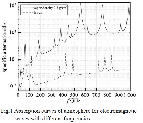
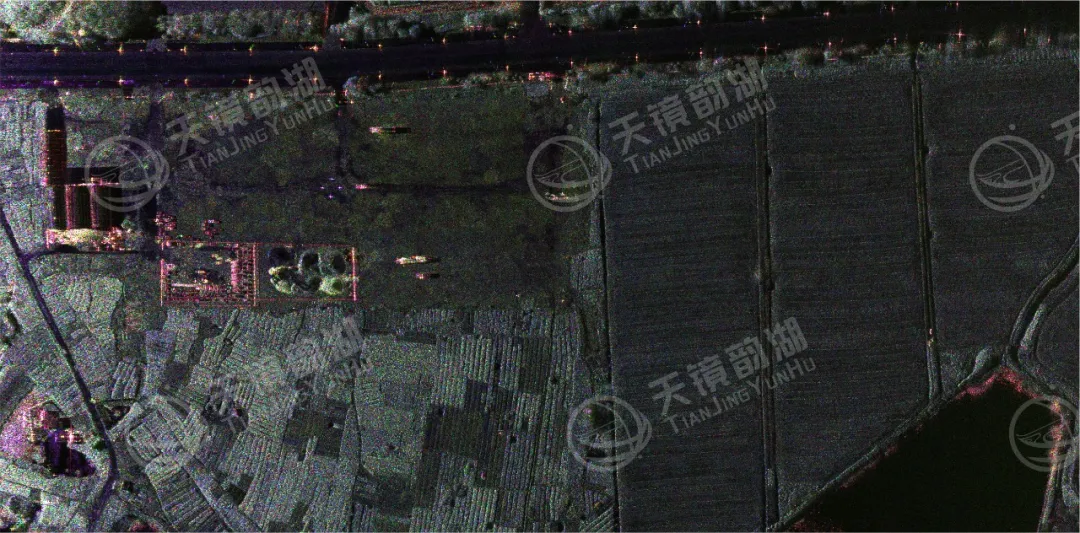
在合成孔径雷达(SAR)家族中,W波段(75GHz-110GHz)以其独特的高频段优势,成为精准感知领域的“细节捕手”。相较于传统波段SAR,W波段凭借极短波长实现了0.1米级的超高成像精度,同时具备轻量化机身特性,尤其适配机载平台应用,在军民两大领域开辟了广阔的应用空间,成为科技赋能安全与发展的重要支撑。
二、应用领域

1民用领域

A.电网巡检搭载该波段SAR的无人机可灵活穿梭于城市楼宇与山区峡谷的输电走廊,凭借0.05米的分辨率捕捉绝缘子毫米级裂纹、导线上的微小异物等隐患,单日巡检效率达数百公里,远超人工巡检的10公里/天。

B.灾害应急领域穿透性优势更为突出,在山体滑坡、洪涝等灾害现场,能穿透烟尘、雨雾遮挡,精准传回受灾范围、积水深度等关键信息。

C.资源管理领域结合深度学习算法,精准区分树种、监测森林病虫害,还可敏感探测土壤湿度

2军事领域

A.伪装评估该波段SAR能识破伪装网的遮挡,清晰呈现装甲车辆的履带轮廓、金属部件等细节,即便目标关闭发动机,也能捕捉到0.1赫兹的微小振动,快速完成目标识别与定位。

B.战场侦察W波段SAR可集成于微型无人机、装甲车等小型作战平台,在城市巷战中实现“隔墙观物”,实时传回室内人员活动、障碍分布等影像,为特战部队提供精准态势感知

C.电子对抗:依托超高分辨率成像与实时处理能力,W波段SAR可在强电磁干扰环境下稳定工作,自动识别敌方雷达阵地、通信节点等辐射源位置,并同步生成三维地形匹配图,支撑精确制导与火力打击闭环。
三、平台适配性

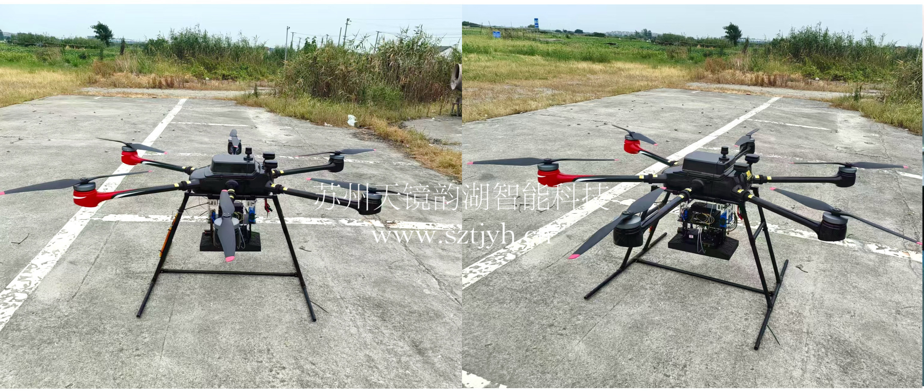
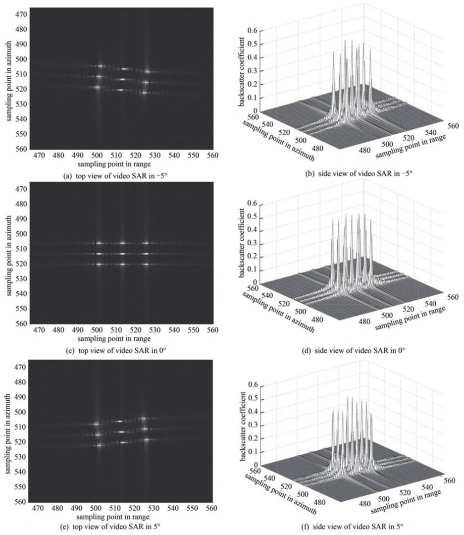
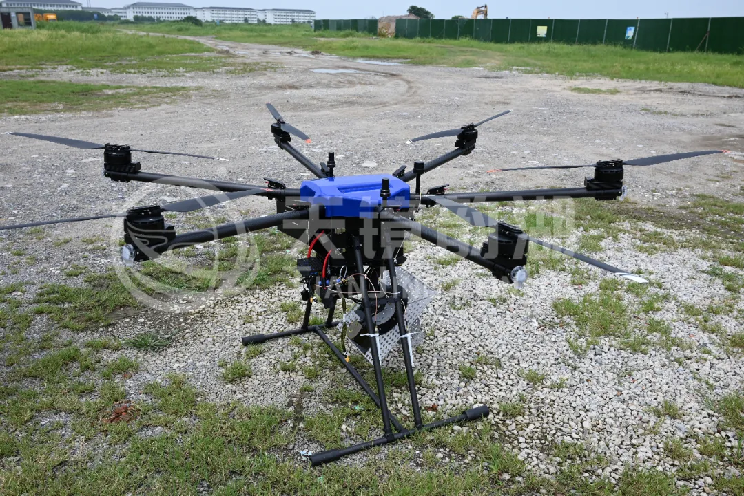
W波段机载合成孔径雷达系统,凭借轻量化设计(重量仅2-3公斤),可灵活搭载于各类无人机,实现高分辨率视频成像与实时监测。

四、机载微型sar系统

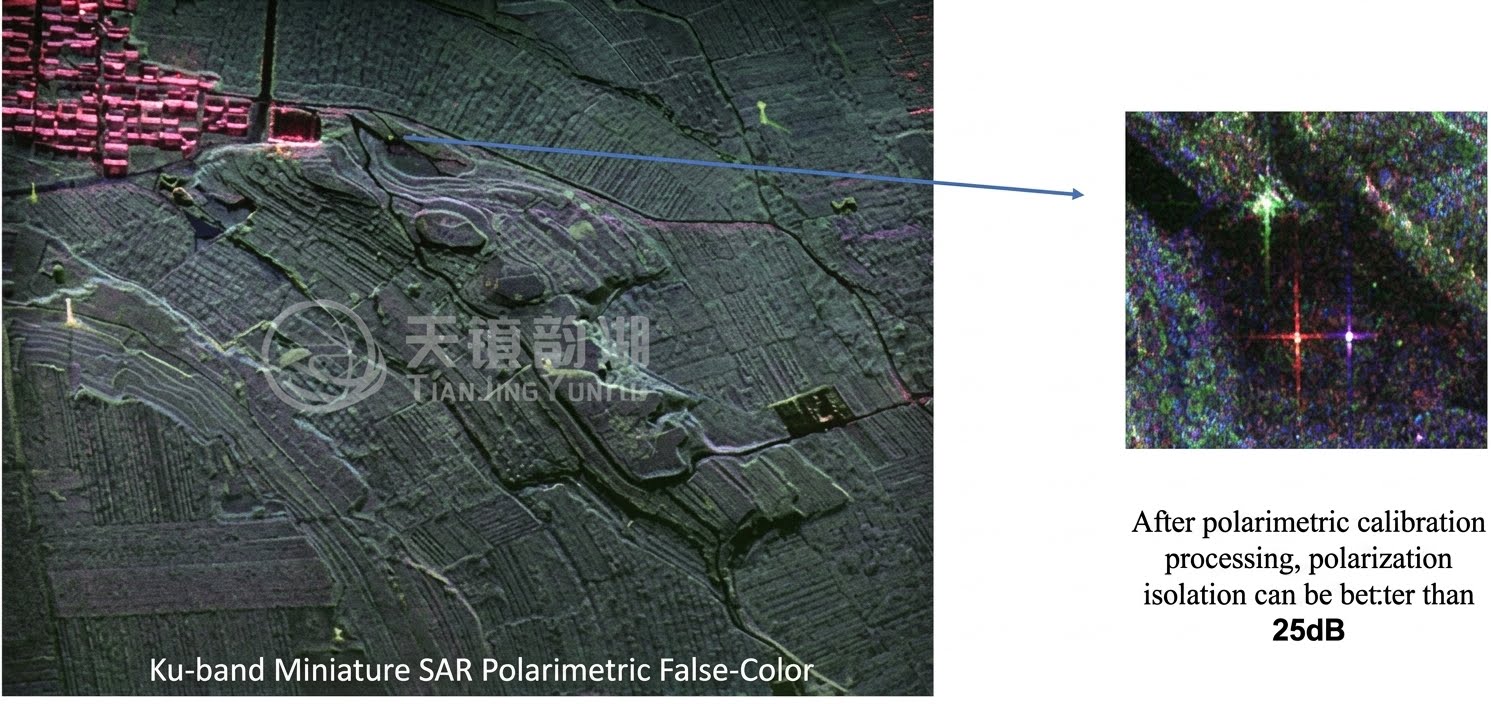
苏州天镜韵湖智能科技有限公司(简称:天镜韵湖)致力于成为全球领先的合成孔径雷达方案解决商,为用户提供定制化雷达设备、SAR数据采集服务、雷达数据产品。天镜韵湖凭借多年的研发经验和专业技术积累,推出了多个波段、具备多种能力的调频连续波及脉冲体制的SAR产品。目前,天镜韵湖已具备X、Ku、K、Ka、C、W、L等多个波段的覆盖,且产品系统具备单极化、全极化、条带、聚束、干涉、单脉冲搜索等模式,产品具有实时成像、GMTI、形变监测等功能。天镜韵湖SAR产品可搭载多旋翼/固定翼无人机、有人机、卫星及车载等平台。
Related Information

Related Information
2026.08.28

Tianjing Yunhu | MiniSAR: Full Polarimetric Imaging Capability

In the field of remote sensing today, synthetic aperture radar (SAR), visible light, and infrared together form a multi-layered observation system. Visible light remote sensing is intuitive and clear, while infrared remote sensing excels at thermal sensing. However, both are passive detection methods, heavily reliant on sunlight or the target's own thermal radiation. Once they encounter cloud cover, nightfall, or rainy/foggy weather, their detection capabilities are significantly reduced or even completely lost.
2026.08.26

Tianjing Yunhu | P-band Airborne SAR Radar System

Low-frequency radars (such as P-band and L-band radars) can "see farther and see more clearly" because of their longer wavelengths, lower attenuation, and reduced sensitivity to stealth coatings. In modern air defense systems, they are key to anti-stealth radars. They can penetrate 1-meter-thick camouflage netting and 3-meter-thick bushes to identify hidden tanks and radar stations, and are less likely to trigger enemy warning systems, demonstrating significant advantages in covert detection.
2026.08.21

Tianjing Yunhu | Miniature SAR Vehicle Target Dataset

Synthetic Aperture Radar (SAR) target detection datasets are a core foundation for training and evaluating deep learning models. These datasets cover various target types, including ships, aircraft, vehicles, bridges, and oil tanks, and are applicable to multiple fields such as military reconnaissance, maritime monitoring, and traffic management. They not only provide high-resolution SAR images but also contain precise annotation information (category, location, size, etc.), ensuring improved algorithm performance.
2026.08.17

Tianjing Yunhu | Miniature SAR Equipped with Fixed-Wing UAV

Today's main focus is on the CW-25E VTOL fixed-wing UAV and the Tianjing Yunhu XiangYun System pulse MiniSAR.

The CW-25E is a pure electric VTOL fixed-wing UAV designed specifically for large-area missions. It has a fuselage length of 2.08 meters, a wingspan of 4.35 meters, and features a twin-boom fused inverted V-tail design, resulting in a compact structure and excellent aerodynamic performance.

The CW-25E has a maximum takeoff weight of 31.58 kg and a payload capacity of 6.6 kg, capable of simultaneously carrying various mission equipment such as SAR, lidar, and electro-optical pods. It boasts a maximum endurance of 150 to 240 minutes, a service ceiling of 6000 meters, a maximum takeoff altitude of 4000 meters, and wind resistance up to level 7. It can stably perform patrol missions in complex terrain and high-altitude areas.
2026.07.18

Tianjing Yunhu | Airborne SAR (Synthetic Aperture Radar) Calibration Capability

Airborne SAR (Synthetic Aperture Radar) calibration refers to the calibration of various parameters of an airborne SAR system using specific methods to eliminate systematic and environmental errors, thereby ensuring the quality of SAR images, positioning accuracy, and the accuracy of inversion parameters. Airborne SAR calibration is mainly divided into three categories: geometric calibration, radiometric calibration, and polarimetric calibration.
2026.07.13

UAV L-band Heavy Orbit Interferometric SAR System: Airborne Verification for Millimeter-Level Deformation Monitoring

Synthetic Aperture Radar Interferometry (InSAR) technology, with its all-weather, 24/7 capability and high sensitivity to surface deformation, has become an important tool for geological hazard monitoring, ground subsidence investigation, and infrastructure health diagnosis. Integrating InSAR technology onto unmanned aerial vehicle (UAV) platforms further overcomes the limitations of long satellite revisit cycles, insufficient maneuverability, and high costs associated with manned operations, providing a new approach for regional, high-frequency, and high-precision deformation monitoring. However, the small size and susceptibility of UAV platforms to airflow disturbances make it difficult to maintain consistent flight paths during repeated flights, posing a significant challenge to double-track interferometry processing.

Online Message

Company Address

Company Address

Room 801, Building 14, No. 135 Zhangji Road, Kunshan Development ZoneView the map
Emaile

Email

tjyh888@139.com
Postal Code

Postal Code

215300
Sales contact information

Sales contact information

  • Sales 1:18252999418 (same WeChat)
  • Sales 2:13126758269 (same WeChat/Whatsapp)
  • Sales 3:15862678208 (same WeChat)
  • Sales 4:15895462772 (same WeChat/Whatsapp)
验证码
Submit

Contact Us

关注我们
关注我们