

In the world of remote sensing, airborne synthetic aperture radar (SAR) is hailed as an "all-weather, all-time" eye. It doesn't rely on sunlight and can penetrate darkness and fog, but this is merely its basic capability.
Even more astonishing is its "penetrating power"—it can see through surface obstructions like X-rays, revealing the truth hidden by vegetation, soil, and even ruins.
However, not all radars possess the same penetrating power. The choice of frequency band determines which layer of the world we can see. Today, we'll discuss the L-band, Ku/X-band, and Ka/W-band—three "masters of seeing through"—and how they each demonstrate their unique abilities in practical applications.
First Level: L-Band – The Hidden "X-ray Vision"
If radar is X-ray vision, then the L-band (1-2GHz) is like a highly skilled traditional Chinese medicine doctor, adept at "observing the qi" (seeing deep structures).
Core Principle
The L-band has the longest wavelength (15-30 cm) and the lowest frequency. According to the laws of physics, the longer the wavelength, the stronger the penetrating power. It can easily penetrate dense forest canopies, reaching the forest floor and even penetrating more than half a meter into dry soil.
Real-world Case: A "CT Scan" of the Hainan Rainforest
In traditional optical imaging, the Hainan rainforest appears as an impenetrable green sea, where we can only see the tops of the treetops. However, a research team from the Chinese Academy of Sciences used airborne L-band SAR to complete a "CT scan" of 27,400 square kilometers of rainforest.
What they saw: Radar waves penetrated layers of leaves, accurately capturing the undulating terrain under the forest canopy, the distribution of tree trunks, and even retrieving the height of individual trees (with an accuracy better than 5 meters). Value: This not only tells us how tall the trees are, but also what's underground. This is crucial for calculating forest carbon storage and protecting biodiversity.
Applicable Scenarios:
Forest Resource Survey: Penetrating the canopy to observe understory topography and biomass.
Geological Exploration: In arid regions, detecting shallow underground structures or groundwater depth.
Polar Monitoring: NASA data shows that the L-band can penetrate more than 1 meter of dry snow, monitoring minute deformations beneath ice sheets.
Second Level: Ku/X-bands—A Microscope for Detailed Observation
If the L-band sees the "inner workings," then the Ku-band (12-18 GHz) and X-band (8-12 GHz) see the "outer surface." They are experts in high-precision surface imaging.
Core Principle:
These two bands have shorter wavelengths and weaker penetrating power (the X-band can only penetrate 1-7 cm in soil, and the Ku-band is almost zero), but extremely high resolution. Extremely sensitive to minute changes in the Earth's surface, they are the preferred choice for creating "high-definition maps."
Case Study 1: "Urban Sketch" of Tongzhou, Beijing
For creating detailed 3D models of a city, the L-band is too blurry; the Ku/X-band is the best choice. The X-band SAR system carried by the domestically developed Hongtu-1 satellite has conducted "tomographic imaging" of the Tongzhou urban area in Beijing.
What was seen: High-precision 3D point cloud data, clearly outlining the contours of each building, roof structure, and street details.
Value: Provides radar data as clear as "optical photographs" for urban planning and the refined operation and maintenance of infrastructure.
Case Study 2: "Ruins Detective" of the Luding Earthquake
In 2022, a 6.8 magnitude earthquake struck Luding, Sichuan. Heavy rain and fog rendered optical satellites "blind." The surveying and mapping emergency team dispatched a Rainbow-4 UAV equipped with Ku-band SAR.
What was observed: Despite its weak penetrating power, the Ku band, with its high resolution, clearly identified details of road collapses and damaged buildings, even distinguishing the edges of landslides.
Value: In severe weather, it provided rescue teams with precise "ruin maps," indicating lifelines.
The Third Level: Ka/W Bands – The "Flash" Through Clouds and Fog
The Ka band (24-40GHz) and W band (75-100GHz) are the "sprint champions" of the radar family. They have extremely short wavelengths and the weakest ability to penetrate the ground surface, but they possess near-optical-grade resolution and can easily penetrate clouds and light fog.
Core Principle
Although they cannot penetrate soil, they can penetrate "clouds and fog" that hinder optical imaging. The W band has a resolution of up to 0.05 meters, capable of seeing road markings and small structures.
Case Study 1: The "Eye in the Clouds" of the Haihe River Flood Disaster
During the devastating Haihe River floods of 2023, thick clouds covered the disaster area. At this critical moment, an aerial platform equipped with Ka-band SAR stepped in.
What it saw: It pierced through the thick clouds, clearly delineating the flooded area and even revealing details of the damage to submerged houses.
Value: It provided real-time disaster data to the command center, enabling precise deployment of relief resources.
Case Study 2: The "Detail-Oriented" Approach to Military Reconnaissance
In a multi-band micro SAR UAV system, the Ka-band was responsible for the final "confirmation" stage.
What it saw: It could clearly identify the precise location and structural details of ground missile launchers.
Value: After macro-level reconnaissance (L-band) identified the target area, the Ka-band provided "conclusive evidence," ensuring the accuracy of the strike.
Selection Guide: How to Pair a "X-ray Vision" for a Mission?
To facilitate everyone's application in practical work, I have summarized a simple selection comparison table:
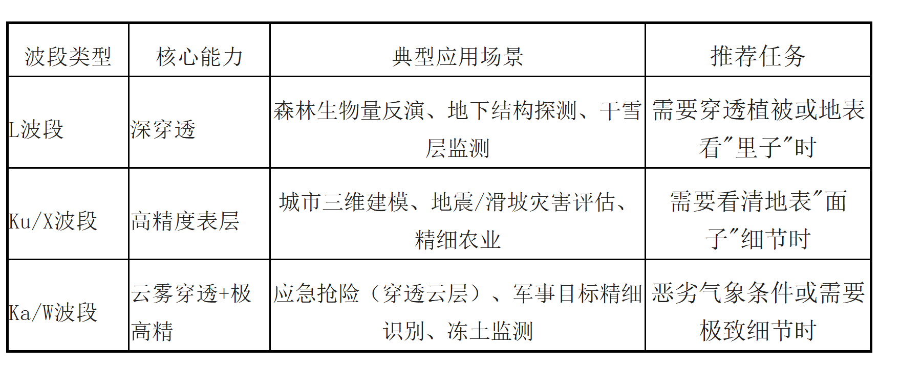
Future Trends: From "Going it Alone" to "Teamwork"
Single-band radar always has limitations; the future direction is multi-band fusion.
Imagine this scenario:
In a complex geological disaster rescue operation, we no longer rely on a single radar system.
The L-band penetrates the rubble layer to search for potential habitats.
The Ku-band delineates the fine structure of the rubble surface, planning the routes for rescue robots.
The Ka-band penetrates overhead clouds, transmitting a real-time global situational awareness map.
Multi-band collaboration not only allows us to "see clearly" but also to "see through."
This is not merely a technological upgrade but also an ultimate pursuit of life and truth. With upgrades in payload technology and optimization of algorithms, airborne SAR will unlock more new scenarios for remote sensing, providing stronger support for industry applications.
Conclusion
From single black-and-white radar images to today's multi-dimensional observations integrating different band characteristics, our ability to observe the Earth is undergoing a silent revolution. This is not only a technological victory but also another leap forward in humanity's exploration of the unknown boundaries. In the skies of the future, every drone equipped with a multi-band SAR system will become a smart eye for observing the world.
Airborne Miniature SAR System
Suzhou Tianjing Yunhu Intelligent Technology Co., Ltd. (hereinafter referred to as Tianjing Yunhu) is committed to becoming a leading global provider of synthetic aperture radar (SAR) solutions, offering users customized radar equipment, SAR data acquisition services, and radar data products. Leveraging years of R&D experience and professional technical accumulation, Tianjing Yunhu has launched SAR products with multiple bands and various capabilities, including frequency-modulated continuous wave (FM) and pulse systems. Currently, Tianjing Yunhu has coverage across multiple bands, including X, Ku, K, Ka, C, W, and L, and its product systems support single-polarization, full-polarization, strip, spotlight, interferometric, and single-pulse search modes. The products feature real-time imaging, GMTI, and deformation monitoring functions. Tianjing Yunhu SAR products can be mounted on multi-rotor/fixed-wing UAVs, manned aircraft, satellites, and vehicle-mounted platforms.








