
Tianjing Yunhu | Why Is Synthetic Aperture Radar (SAR) Made So Lightweight?

Browse: 27 Time: 2026-10-16

Synthetic Aperture Radar (SAR) actively emits electromagnetic waves and receives the reflected echoes. This unique imaging mechanism endows SAR with all-time, all-weather penetrating imaging capability, making it one of the indispensable technologies in the remote sensing field for more than half a century since SAR first emerged.

Early SAR systems often weighed hundreds of kilograms and could only be carried on large manned aircraft or satellite platforms. In recent years, however, as SAR remote sensing technology has gradually spread, a lightweight revolution has been quietly taking place worldwide. Lightweight and compact design is becoming the "inevitable trend" for international airborne SAR.
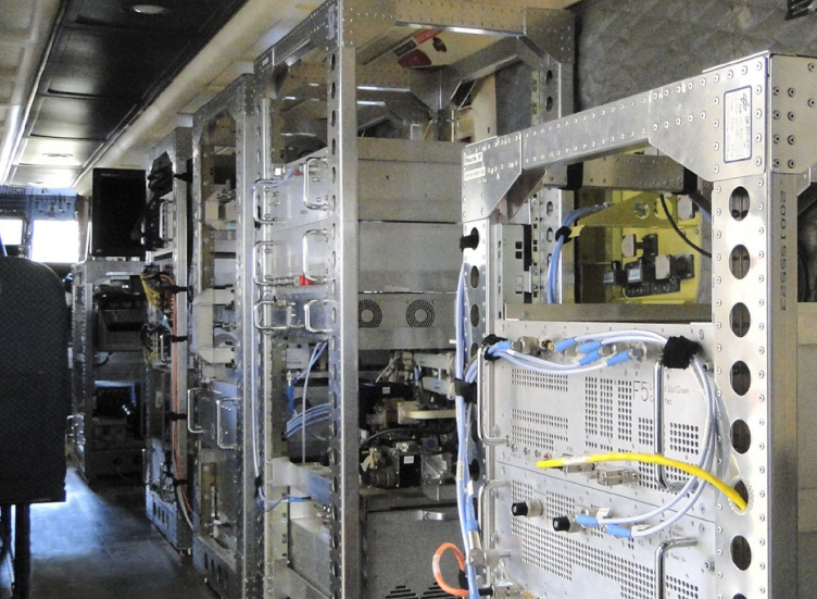
Traditional airborne SAR systems

In 2025, the global synthetic aperture radar market reached USD 5.13 billion and is projected to grow to USD 7.96 billion by 2032. (Industry data in this article is sourced from the internet and is for reference only.) The core driver behind this growth is precisely the miniaturization and lightweight design of SAR systems. Internationally, the major players have already made their moves. Boeing, Insitu, and the Netherlands-based TNO jointly advanced the MRaISR program in 2025, aiming to design a low-SWaP (Size, Weight, and Power) multi-mode SAR radar that gives small and medium-sized UAVs the all-weather reconnaissance and intelligence-gathering capabilities previously reserved only for large platforms. At the DSEI 2025 defense exhibition in London, U.S. company IMSAR showcased its low-SWaP SAR radar, sparking strong industry interest in "advanced radar solutions for maritime, ground, and aerial missions." Poland's SpaceForest launched the HUSSAR radar in 2024, weighing from just 5 kg, designed specifically for rotorcraft UAVs with a 5–10 kg payload. Turkey's ASELSAN developed the FULMAR-200 SAR pod system in 2024, also emphasizing lightweight and compact design.
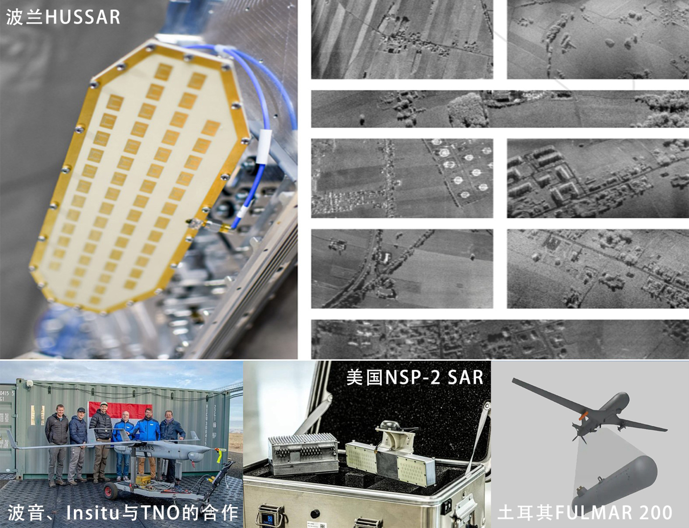
Why is the whole world moving toward "lighter"? Because the shackles of "expensive, bulky, and platform-restricted" traditional SAR systems are forcing the entire industry to innovate. The combination of Frequency Modulated Continuous Wave (FMCW) technology with SAR has made it possible to build lightweight, high-resolution imaging sensors. Compared with traditional SAR systems, it offers notable advantages: lower cost, smaller size, lower power consumption, and lighter weight.

Our Lingyun series of miniature SAR payloads integrates a high-precision inertial navigation system, a high-performance servo-stabilized gimbal, an RF antenna, and supporting data-link and power-supply modules. The entire unit weighs only 2.7 kg or even less, with power consumption as low as 120 W. Behind this achievement lies our sustained, focused R&D effort across multiple technical fronts, including RF integration, antenna miniaturization, and low-power design.
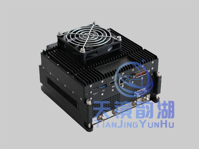
Lingyun series product image

More importantly, lightweight design has never come at the expense of performance. The system has been successfully integrated into industry-grade low-payload UAV platforms such as the DJI M400 and JOUAV CW-15, and has completed multiple real-world aerial-survey validations. Whether in radiometric calibration accuracy, polarization isolation, or post-processing imaging accuracy, our technical specifications reach industry-leading levels, offering the following advantages:

1、More flexible platform selection: At around 2 kg, the payload can be mounted on multirotor UAVs such as the DJI M400, and can also be adapted to fixed-wing UAVs such as the CW-15 — from multirotor to fixed-wing, from electric to gasoline-powered, it is nearly universal.

2、Drastically lower deployment cost: No runway, no large airport, and no ground-crew team required. Two people, one vehicle, and one computer — ready to take off and operate anytime, anywhere.

3、Faster response: When a disaster strikes, you have to wait for satellite revisit cycles and for the scheduling of large aircraft. With lightweight UAV-borne SAR, you can take off the same day and deliver imagery the same day.

4、Multiplied mission frequency: The low cost brought by lightweight design makes high-frequency, long-cycle routine monitoring possible — and this is precisely the core requirement for applications such as deformation monitoring, agricultural yield estimation, and urban planning.
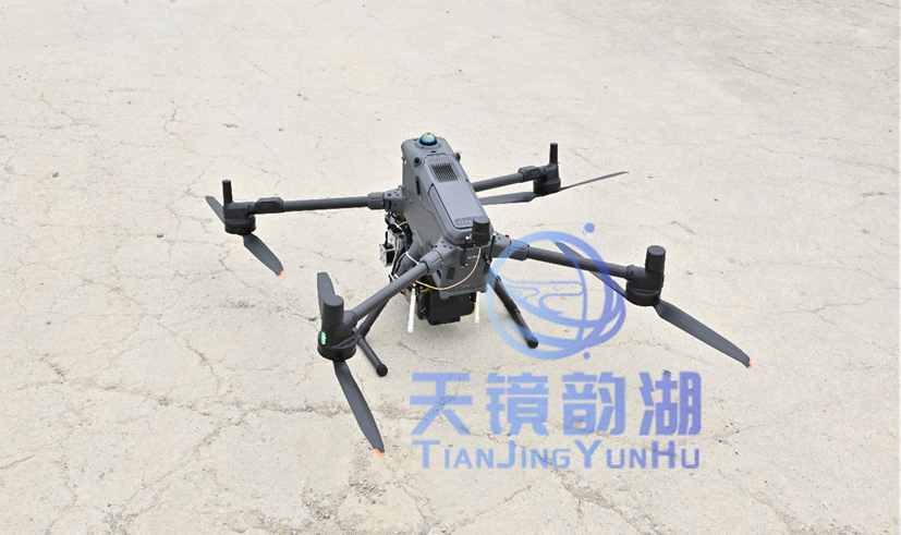
Mounted on the DJI M400
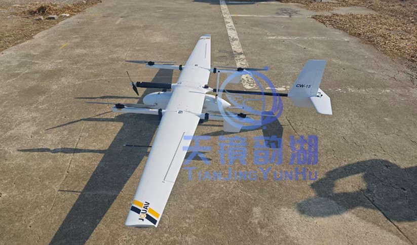
Mounted on the JOUAV CW-15

In the field of airborne SAR, we are opening a new track through technological innovation, focusing on lightweight, low-cost solutions that meet the needs of consumer-grade UAVs and radar data services. Making SAR lightweight is not only about keeping up with industry trends, but more importantly, about letting more people use SAR and taking SAR to more places that need it. We are committed to bringing domestic SAR from niche to mainstream, making synthetic aperture radar truly an accessible, efficient, and reliable Earth-observation tool!


Related Information

Related Information
2026.08.28

Tianjing Yunhu | MiniSAR: Full Polarimetric Imaging Capability

In the field of remote sensing today, synthetic aperture radar (SAR), visible light, and infrared together form a multi-layered observation system. Visible light remote sensing is intuitive and clear, while infrared remote sensing excels at thermal sensing. However, both are passive detection methods, heavily reliant on sunlight or the target's own thermal radiation. Once they encounter cloud cover, nightfall, or rainy/foggy weather, their detection capabilities are significantly reduced or even completely lost.
2026.08.26

Tianjing Yunhu | P-band Airborne SAR Radar System

Low-frequency radars (such as P-band and L-band radars) can "see farther and see more clearly" because of their longer wavelengths, lower attenuation, and reduced sensitivity to stealth coatings. In modern air defense systems, they are key to anti-stealth radars. They can penetrate 1-meter-thick camouflage netting and 3-meter-thick bushes to identify hidden tanks and radar stations, and are less likely to trigger enemy warning systems, demonstrating significant advantages in covert detection.
2026.08.21

Tianjing Yunhu | Miniature SAR Vehicle Target Dataset

Synthetic Aperture Radar (SAR) target detection datasets are a core foundation for training and evaluating deep learning models. These datasets cover various target types, including ships, aircraft, vehicles, bridges, and oil tanks, and are applicable to multiple fields such as military reconnaissance, maritime monitoring, and traffic management. They not only provide high-resolution SAR images but also contain precise annotation information (category, location, size, etc.), ensuring improved algorithm performance.
2026.08.17

Tianjing Yunhu | Miniature SAR Equipped with Fixed-Wing UAV

Today's main focus is on the CW-25E VTOL fixed-wing UAV and the Tianjing Yunhu XiangYun System pulse MiniSAR.

The CW-25E is a pure electric VTOL fixed-wing UAV designed specifically for large-area missions. It has a fuselage length of 2.08 meters, a wingspan of 4.35 meters, and features a twin-boom fused inverted V-tail design, resulting in a compact structure and excellent aerodynamic performance.

The CW-25E has a maximum takeoff weight of 31.58 kg and a payload capacity of 6.6 kg, capable of simultaneously carrying various mission equipment such as SAR, lidar, and electro-optical pods. It boasts a maximum endurance of 150 to 240 minutes, a service ceiling of 6000 meters, a maximum takeoff altitude of 4000 meters, and wind resistance up to level 7. It can stably perform patrol missions in complex terrain and high-altitude areas.
2026.07.18

Tianjing Yunhu | Airborne SAR (Synthetic Aperture Radar) Calibration Capability

Airborne SAR (Synthetic Aperture Radar) calibration refers to the calibration of various parameters of an airborne SAR system using specific methods to eliminate systematic and environmental errors, thereby ensuring the quality of SAR images, positioning accuracy, and the accuracy of inversion parameters. Airborne SAR calibration is mainly divided into three categories: geometric calibration, radiometric calibration, and polarimetric calibration.
2026.07.13

UAV L-band Heavy Orbit Interferometric SAR System: Airborne Verification for Millimeter-Level Deformation Monitoring

Synthetic Aperture Radar Interferometry (InSAR) technology, with its all-weather, 24/7 capability and high sensitivity to surface deformation, has become an important tool for geological hazard monitoring, ground subsidence investigation, and infrastructure health diagnosis. Integrating InSAR technology onto unmanned aerial vehicle (UAV) platforms further overcomes the limitations of long satellite revisit cycles, insufficient maneuverability, and high costs associated with manned operations, providing a new approach for regional, high-frequency, and high-precision deformation monitoring. However, the small size and susceptibility of UAV platforms to airflow disturbances make it difficult to maintain consistent flight paths during repeated flights, posing a significant challenge to double-track interferometry processing.

Online Message

Company Address

Company Address

Room 801, Building 14, No. 135 Zhangji Road, Kunshan Development ZoneView the map
Emaile

Email

tjyh888@139.com
Postal Code

Postal Code

215300
Sales contact information

Sales contact information

  • Sales 1:18252999418 (same WeChat)
  • Sales 2:13126758269 (same WeChat/Whatsapp)
  • Sales 3:15862678208 (same WeChat)
  • Sales 4:15895462772 (same WeChat/Whatsapp)
验证码
Submit

Contact Us

关注我们
关注我们




