

I. LiDAR and SAR: Twin Stars, Each with Its Own Strengths
Before understanding SAR, it's crucial to clarify the value of LiDAR. The two are not substitutes, but rather complementary in various applications:
1. LiDAR: The "3D Painter" of Fine Mapping
• Principle: Like rapidly waving a flashlight (laser beam) in the dark, it calculates the light reflection time to precisely measure distances, generating 3D point clouds with centimeter-level accuracy.
• Advantages: In clear weather, it can accurately reconstruct terrain, building, and vegetation details, making it a core technology for surveying, urban planning, and autonomous driving.
• Limitations: Lasers are easily scattered by rain, fog, and dust; auxiliary light sources are needed at night; and it cannot operate in adverse weather conditions.
2. Airborne SAR: The "Strategic Radar" That Pierces Through Clouds and Fog
• Principle: It actively emits microwaves that penetrate clouds, rain, darkness, and even thin vegetation to receive ground reflection signals and generate images, excelling at detecting surface changes.
• Advantages: Truly "all-weather, all-time" operation, capable of monitoring millimeter-level surface displacement, providing the only reliable intelligence in extreme weather and darkness.
• Core Value: When LiDAR "goes blind" due to weather, SAR takes over as the "last information channel."
II. Technological Origins: The Underlying Differences Between the Two Remote Sensing Technologies from Principle to Output
Airborne SAR and airborne LiDAR both belong to active remote sensing technologies (actively transmitting signals to the ground and receiving echoes), but their signal carriers, measurement logic, and data results are completely different, which determines their unique advantages in disaster relief.
(1) Airborne LiDAR: The "Three-Dimensional Precision Mapper" of Laser Ranging
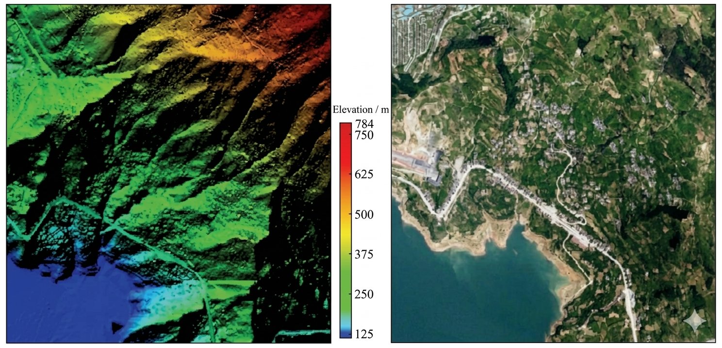
Airborne LiDAR is an optical laser ranging remote sensing technology. It transmits high-density laser pulses to the ground through airborne equipment, records the time difference between the laser's round trip to the ground, and directly calculates the X, Y, and Z three-dimensional coordinates of every point on the ground, forming massive three-dimensional point cloud data. The high directionality and precision of lasers make them the "gold standard" for topographic mapping, achieving centimeter-level accuracy in both horizontal and vertical mapping.
Processed point cloud data can generate DSM (Digital Surface Model), DTM (Digital Terrain Model), and DEM, capable of reproducing the true morphology of mountains, buildings, rivers, and vegetation at a 1:1 scale. Even details like tilted buildings, cracks in mountains, and silted-up rivers can be accurately depicted. However, lasers operate in the optical band and cannot penetrate clouds, dense fog, heavy rainfall, or dense vegetation canopies, limiting their operation to clear weather conditions.
In short: SAR uses microwaves to "observe changes and measure dynamics," while LiDAR uses lasers to "measure shapes and pinpoint locations." One is static, the other dynamic; one is coarse, the other precise, forming a complete closed-loop capability for emergency remote sensing.
(2) Airborne SAR: A "Dynamic Deformation Monitor" with Microwave Penetration
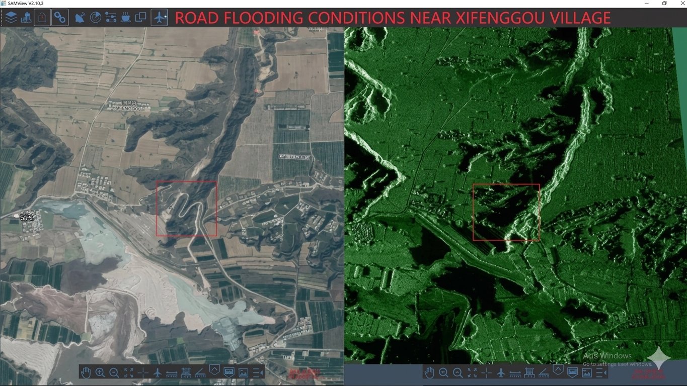
Airborne SAR is a microwave coherent imaging remote sensing technology. It utilizes the flight trajectory of an aircraft/UAV platform to synthesize a virtual long antenna, transmitting microwave signals in different bands such as L, P, and X to the ground. High-resolution two-dimensional images are generated by analyzing the amplitude, phase, and polarization information of the echoes. Its core capability is not simply "taking pictures," but capturing minute surface deformations—through InSAR (Synthetic Aperture Radar Interferometry) technology, it can accurately identify surface displacements at the millimeter to centimeter level, a breakthrough unattainable by other remote sensing technologies.
In terms of data output, SAR provides intensity images, coherence maps, and DEM (Digital Elevation Model). Its core strength lies in deformation rate maps, which can dynamically track the slow creep of landslides, dams, and fault zones, providing crucial evidence for disaster early warning. More importantly, microwaves possess strong penetrating power, ignoring clouds, fog, rain, snow, dense smoke, and darkness, truly enabling all-weather, 24/7 operation—an irreplaceable advantage during sudden disasters.
II. Three Major "Emergency Rescue Capabilities" of Airborne SAR
1. Weather-Independent "See-Through" Power in Disaster Areas
• Capability: Microwave properties allow it to penetrate clouds, rain, and smoke, enabling active imaging in the dark and clearly "seeing" obscured disaster situations.
2. Millimeter-Level Sensing, a "Warning Device" for Disasters
• Capability: By comparing data from different periods using InSAR technology, it captures millimeter-level displacement of the ground surface, providing early warnings of risks such as landslides and earthquakes.
3. Rapid Response, an "Efficiency Engine" for Emergency Response
• Capability: With miniaturization, the equipment can be rapidly deployed on small and medium-sized UAVs to acquire large-scale disaster maps in the first instance.
III. Core Comparison: Understanding the Division of Labor between LiDAR and SAR
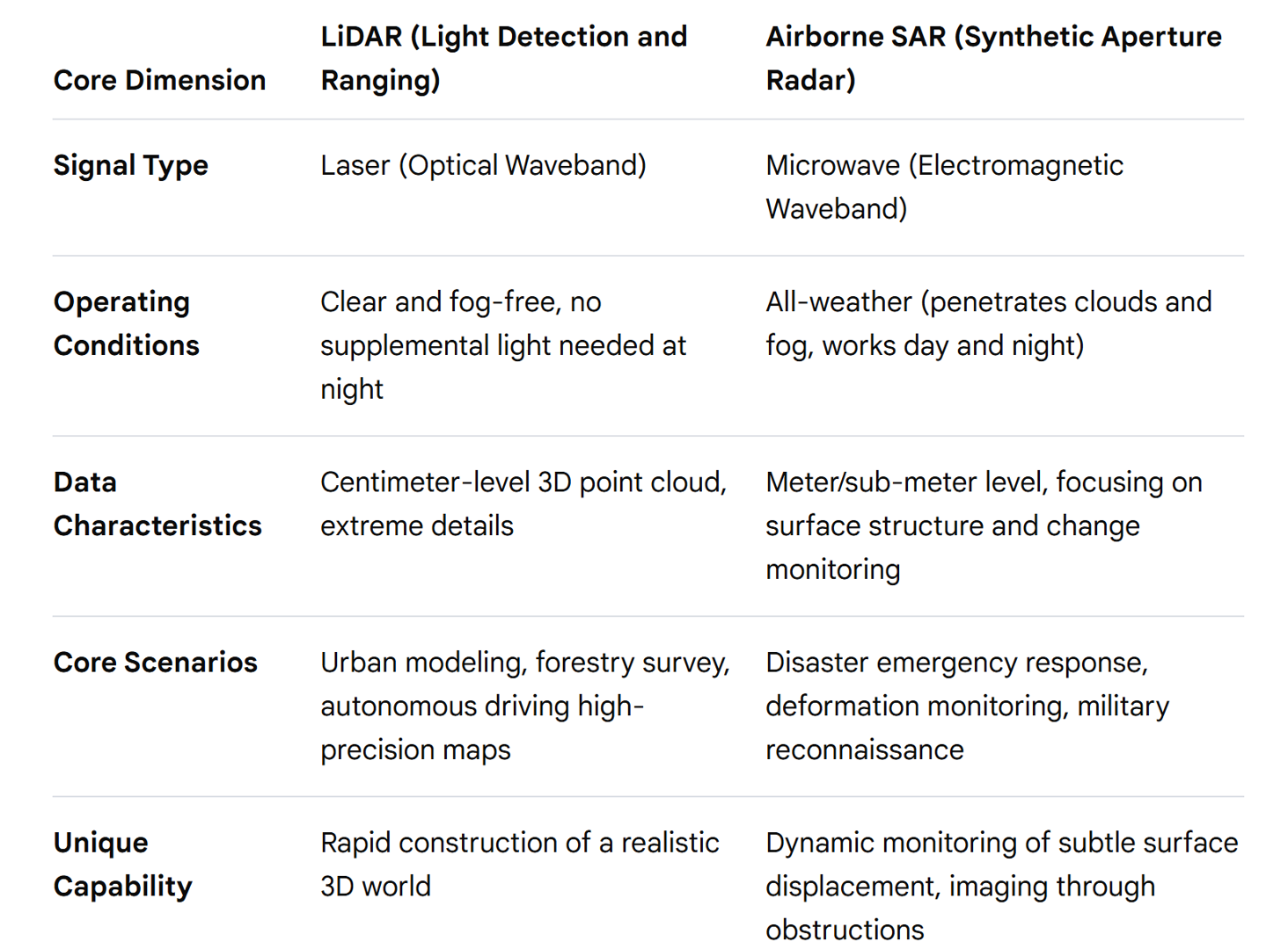
• LiDAR is a "precision mapper," outputting centimeter-level details under ideal conditions;
• SAR is an "emergency vanguard," ensuring uninterrupted information flow even in extreme environments.
IV. Collaborative Future: A "Super Vision" of Technological Convergence
Despite clear division of labor, technological convergence is opening up new possibilities:
• Dual-payload UAVs: A single platform simultaneously carries SAR and LiDAR, acquiring all-weather monitoring and high-precision modeling data in a single flight.
• AI Intelligent Convergence: Algorithms combine the macroscopic situational awareness of SAR with the microscopic details of LiDAR to generate a more comprehensive "digital disaster area," improving emergency response efficiency.
Conclusion: There is no "strongest," only "necessary"
In emergency rescue, LiDAR paves the way for reconstruction with its high precision, while SAR buys lives with its all-weather capabilities. The existence of SAR is not to prove it is stronger than LiDAR, but to fill the "extreme scenarios" that the latter cannot cover—it is the eye that penetrates the clouds in torrential rain, the lighthouse that guides the way in the dark, and the lifeline that provides critical intelligence in the most critical moments of disaster.
True technological power is never the overwhelming dominance of a single technology, but the synergy of multiple capabilities. Understanding this will allow us to face future challenges with greater composure.
V. Airborne Miniature SAR System
Suzhou Tianjing Yunhu Intelligent Technology Co., Ltd. (hereinafter referred to as Tianjing Yunhu) is committed to becoming a leading global provider of synthetic aperture radar (SAR) solutions, offering users customized radar equipment, SAR data acquisition services, and radar data products. Leveraging years of R&D experience and professional technical accumulation, Tianjing Yunhu has launched SAR products with multiple bands and various capabilities, including frequency-modulated continuous wave (FM) and pulse systems. Currently, Tianjing Yunhu provides coverage across multiple bands, including X, Ku, K, Ka, C, W, and L, and its product systems support single-polarization, full-polarization, strip, spotlight, interferometric, and single-pulse search modes. The products also feature real-time imaging, GMTI (Gross-Glass Interference Technology), and deformation monitoring functions. Tianjing Yunhu SAR products can be mounted on multi-rotor/fixed-wing UAVs, manned aircraft, satellites, and vehicle-mounted platforms.








