

Lodging is one of the major disasters restricting the stable and high yields of major grain crops such as corn and wheat. Extreme weather such as strong winds and torrential rains can easily cause root and stem lodging, directly resulting in reduced yields, decreased quality, and significantly increased harvesting and compensation costs. Traditional manual inspections are inefficient, and optical remote sensing depends on sunlight and weather conditions, making it difficult to meet the needs for rapid, accurate, and all-weather monitoring after disasters.
Our company has independently developed an unmanned aerial vehicle (UAV) synthetic aperture radar (SAR) system. Through collaborative research with relevant units, we have broken through industry bottlenecks with technology and deeply integrated high-resolution micro SAR with intelligent algorithms to create a practical, efficient, and high-precision crop lodging monitoring solution, providing core support for agricultural disaster prevention and mitigation, insurance claims, and precision management.
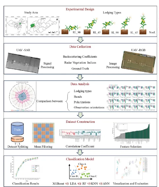
Workflow of crop lodging research
I. Core Technologies: From "Visible" to "Accurate"
(I) Dual-Band High-Resolution Imaging
Equipped with a self-developed X-band + Ku-band miniature SAR radar, the highest spatial resolution reaches 0.15 meters. It can clearly capture changes in the canopy structure of crops in the field, accurately identify root lodging, stem lodging, and different lodging angles and directions, and achieve centimeter-level fine observation.
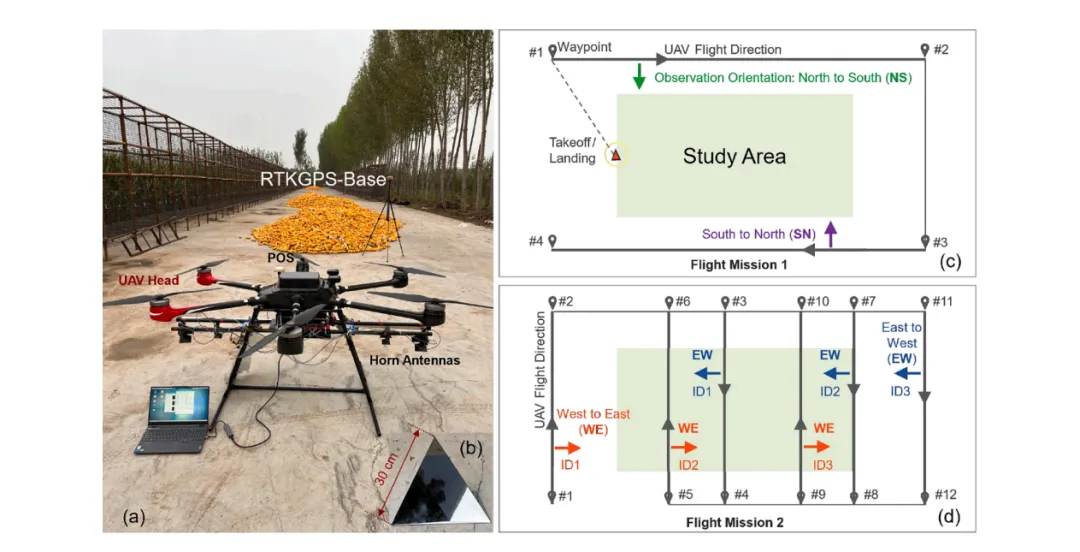
The configuration of the UAV SAR system used in this study is consistent with the flight mission planning route provided by our company.
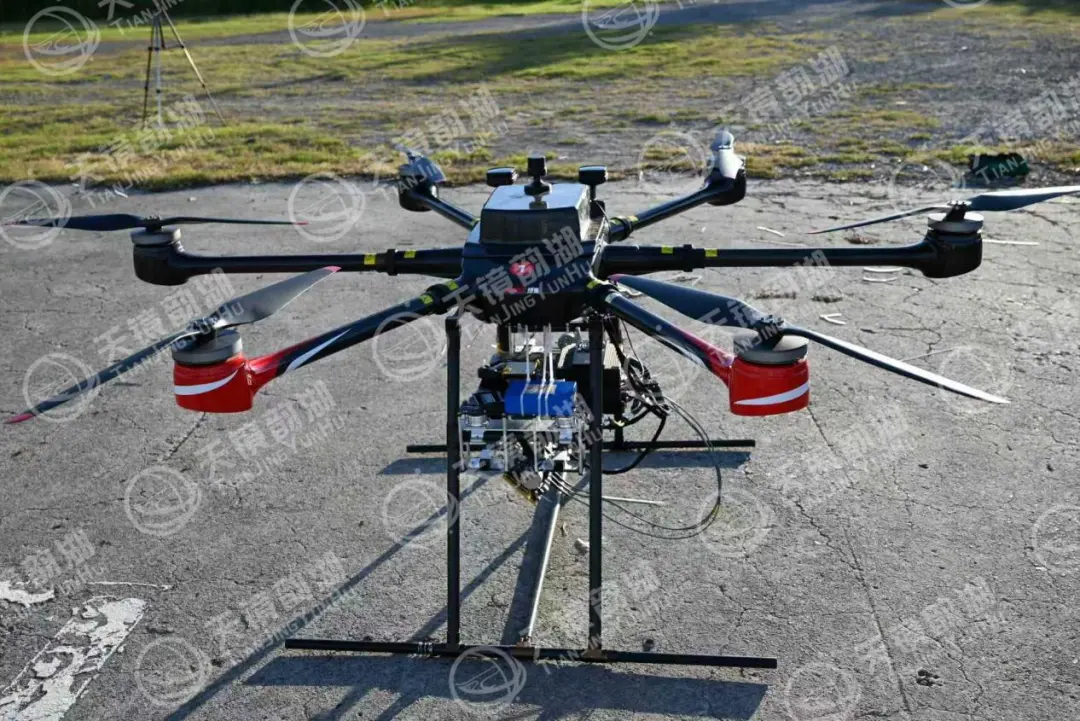
X+KU band configuration and diagram of a hexacopter
(II) Full/Dual Polarization Intelligent Detection
Supports HH/HV/VH/VV multi-polarization working modes. Utilizing the difference between co-polarized and cross-polarized signals, it accurately analyzes the microwave scattering characteristics after crop lodging, distinguishing the type, degree, and orientation of lodging, far exceeding the single-dimensional judgment of traditional optical methods.
(III) Multi-directional and Multi-angle Observation
Supports aerial surveys in multiple directions such as north-south and east-west. The signal response is strongest when the radar observation direction is perpendicular to the lodging direction, effectively identifying complex field lodging distributions and solving the problems of missed or misjudged cases easily encountered with single-angle observations.
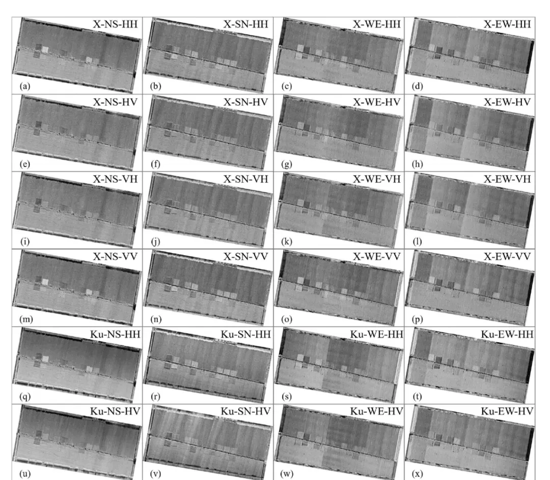
Orthophoto mosaic images of the study area by UAV SAR under different radar parameters
(IV) Accurate Classification via Machine Learning
The built-in RFE feature optimization + ANN intelligent classification algorithm automatically extracts key features such as backscattering coefficient and radar vegetation index, achieving a comprehensive identification accuracy of 98.26% for lodging type, with a Kappa coefficient of 0.982, and the results are stable and reliable.
II. Product Advantages: Truly Solving Industry Pain Points
(I) All-Weather, All-Time Operation
Actively emits microwaves, unaffected by sunlight, clouds, fog, or rain. It can take off immediately after a disaster, overcoming the fatal weakness of optical remote sensing being dependent on weather conditions.
(II) High-Efficiency, Wide-Area Coverage
Single flight covers a wide area, eliminating the need for densely overlapping flight paths. Data processing speed is far faster than UAV RGB 3D reconstruction, producing images and reports within hours, meeting post-disaster emergency needs.
(III) Ultra-High Precision Identification
It can distinguish between 90°/45° root lodging and 90°/45° stem lodging, and identify the direction of lodging. Its accuracy and dimensionality are comprehensively superior to traditional satellite SAR and UAV optical solutions.
(IV) Lightweight and Easy to Deploy
The system is lightweight and integrated, compatible with mainstream hexacopter UAVs. It is simple to operate and flexible to deploy, allowing for rapid use by grassroots agricultural technicians and insurance institutions.
(V) Sky-Based Collaboration, Comprehensive Monitoring
It can complement satellite SAR data, achieving integrated "large-scale general survey + plot-level detailed survey," taking into account both regional disaster situations and field details.
III. Application Value: Empowering the Entire Agricultural Chain
Disaster Emergency Response: Rapidly obtains the scope, severity, and type of damage after lodging, supporting disaster relief decision-making.
Insurance Claims: Accurately assesses losses, quantifies affected area and severity, reduces disputes, and improves claims efficiency.
Plant Management: Assesses variety lodging resistance, guiding optimization of field management such as dense planting and fertilization.
Seed Industry Research: Provides objective and quantitative data support for the breeding of lodging-resistant varieties.
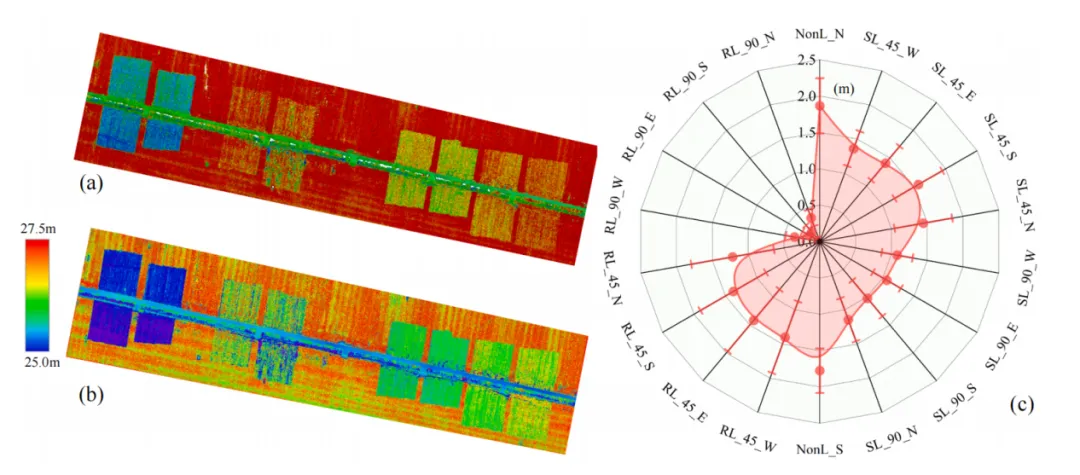
The generated Digital Surface Model (DSM) and radar plots showing the mean and standard deviation of pH for each ROI.
Our company's miniature SAR system was honored to participate in a crop lodging monitoring experiment project for relevant organizations. By combining radar technology with intelligent algorithms, we successfully implemented the fourth core and practical technology for agricultural remote sensing, following spaceborne optics, satellite SAR, and UAV optics. In the future, we will continue to deepen our understanding of agricultural SAR applications, using technology to safeguard food security and contribute to the high-quality development of smart agriculture.








