

Synthetic Aperture Radar (SAR), an all-weather, 24/7 reconnaissance technology, has now moved from military applications to the civilian market, becoming a core sensing tool in numerous fields such as land surveying, disaster response, agricultural monitoring, and marine surveillance. This article will analyze the real differences between spaceborne SAR and airborne SAR, helping you clarify which one to choose!
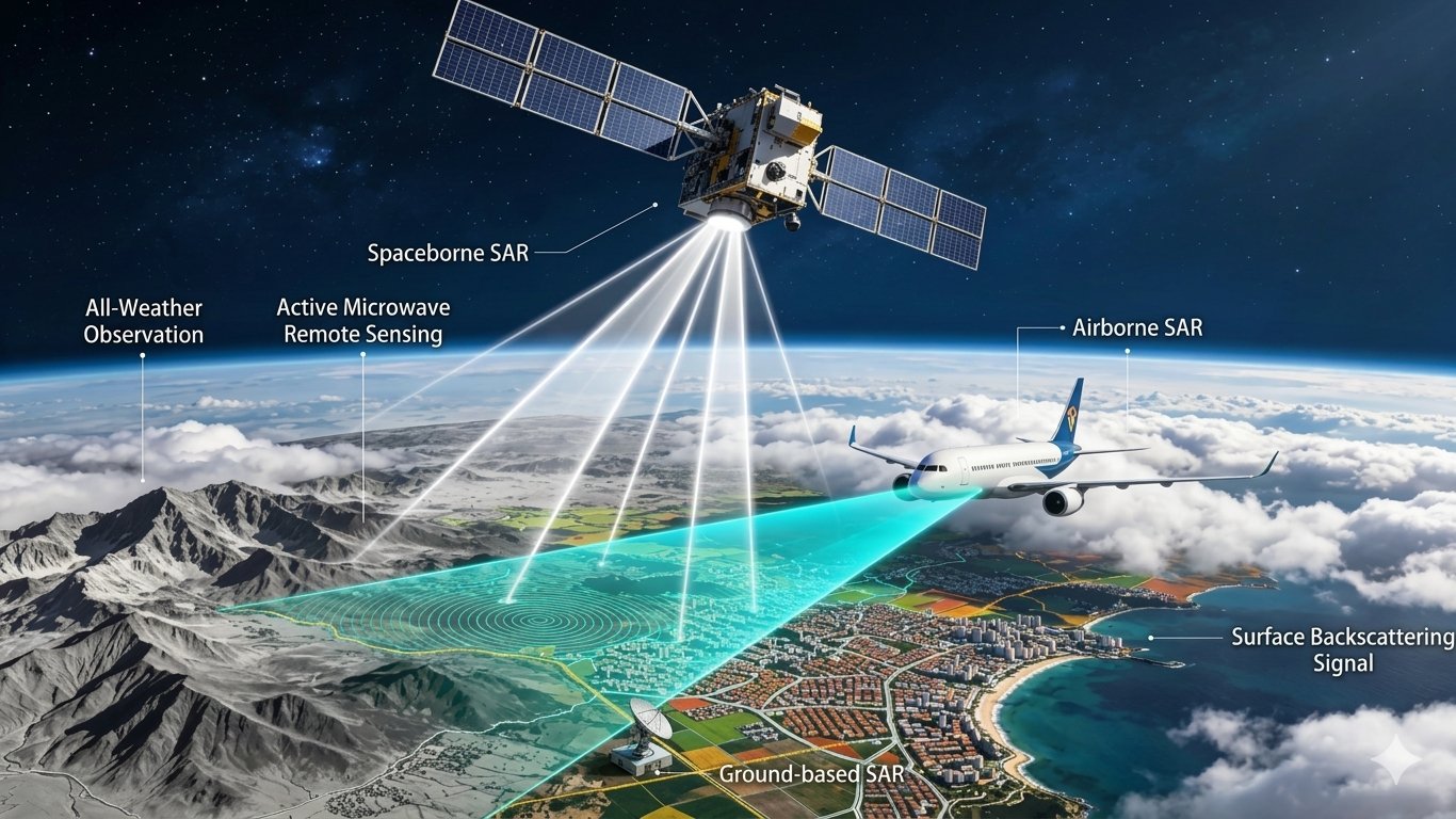
1. Operating Platform and Coverage
Spaceborne SAR, carried by satellites, enables continuous global observation, unrestricted by national borders, making it suitable for long-term, large-scale environmental monitoring, resource surveys, and surface deformation monitoring. However, due to satellite orbit limitations, revisit cycles for specific locations may be long.
Airborne SAR, primarily carried by aircraft or UAVs, has coverage limited by flight distance and area, but offers extremely high flexibility and rapid response capabilities. It can conduct high-density, high-frequency data acquisition at designated times and locations, making it suitable for emergency rescue, military reconnaissance, and localized geological hazard assessment.
2. Data Processing and Resolution
Spaceborne SAR generates large amounts of data, is complex to process, and requires more computing resources. Achieving high resolution is extremely difficult and costly. While top-tier spaceborne systems can achieve resolutions of 0.25 meters or even better, this usually involves trade-offs in imaging swath width and other performance characteristics.
Airborne SAR requires less data processing, has a simpler processing procedure, and can quickly acquire observation results, meeting rapid response requirements. Because it's closer to the target, the system can even achieve centimeter-level resolution, sufficient for various monitoring scenarios.
3. Cost and Flexibility
This is the most direct comparison between the two. Spaceborne SAR has an extremely high lifecycle cost, with investments often reaching millions of dollars from satellite development and launch to on-orbit operation. High maintenance costs make it difficult to iterate technology or temporarily change missions.
In contrast, airborne SAR demonstrates high economic efficiency and flexibility. Its development and deployment costs are far lower than spaceborne systems, allowing more research institutions and commercial companies to own and use it. Furthermore, it can be quickly integrated into different aircraft platforms, rapidly completing aerial survey missions.
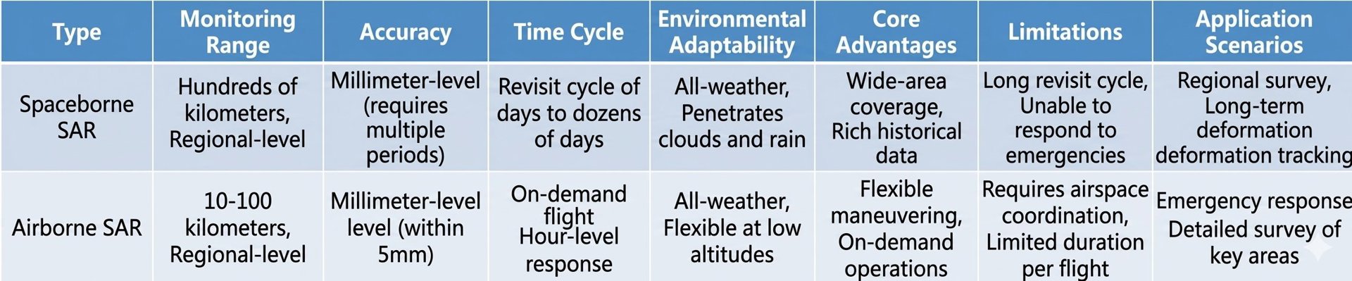
Spaceborne SAR vs. Airborne SAR Summary
If you are looking for a miniaturized, lightweight airborne SAR radar system that can be quickly integrated for flight missions, then our SAR system is the ideal choice you've been searching for. From the outset, our SAR radar system has prioritized "low SWaP" (small size, light weight, and low power consumption) as a core design objective, aiming to break through the stringent platform limitations imposed by traditional large radar systems.
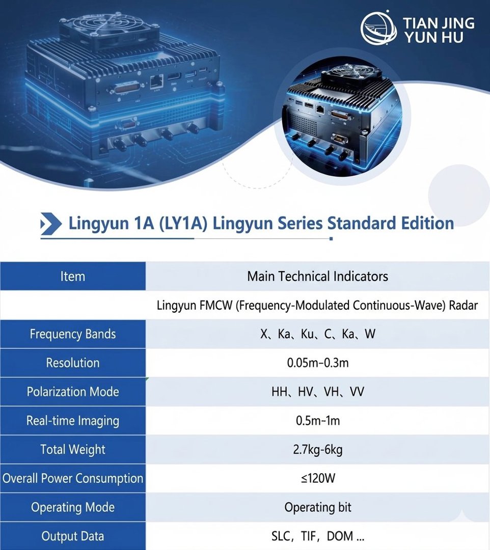
Product Technical Specifications
Ultra-compact and lightweight, highly adaptable to various platforms: Our system achieves unprecedented miniaturization and lightweighting, with a minimum weight of approximately 2 kg. This means it can be easily mounted on various small and lightweight UAVs, even multi-rotor UAVs, making advanced reconnaissance capabilities previously only available on large platforms accessible to everyone.
Plug and play, rapid integration and deployment: The product adopts a modular and integrated design, supporting "plug and play." You can quickly install the radar system on manned or unmanned aircraft without complex modification and integration cycles, and generate images in real time and transmit them synchronously back to the ground via onboard real-time processing and communication links.
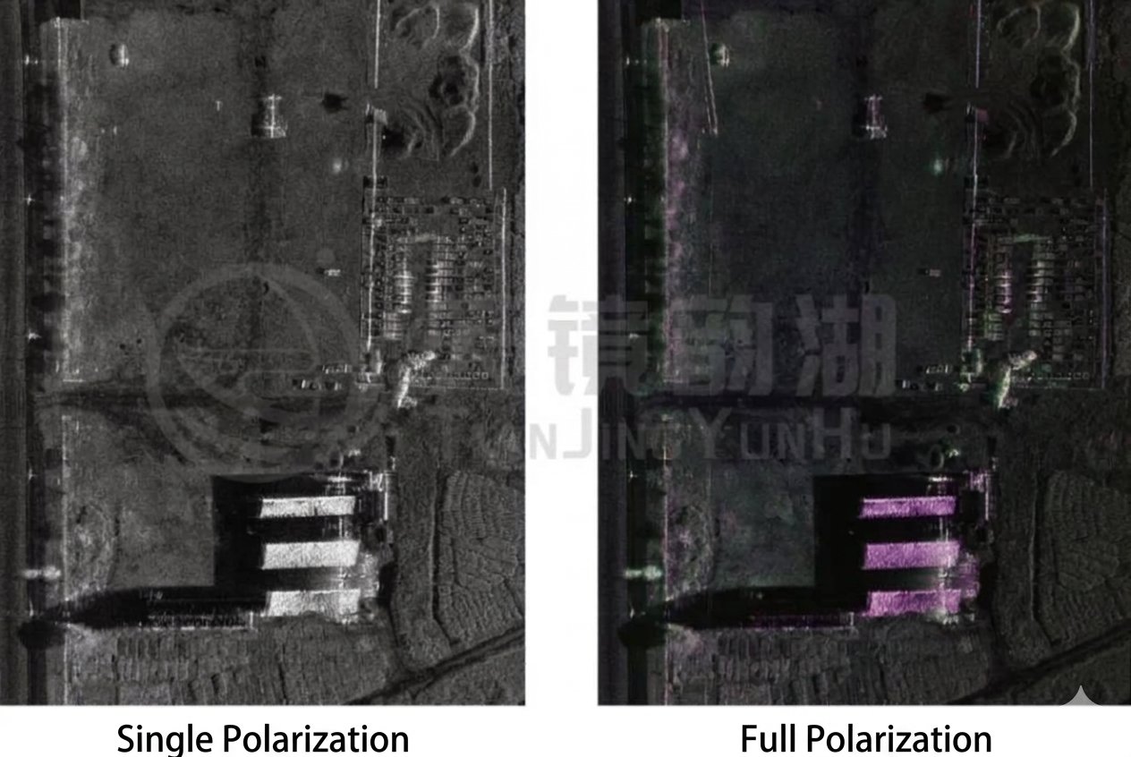
Product Imaging Performance
Suzhou Tianjing Yunhu Intelligent Technology Co., Ltd. focuses on the research and application of miniature synthetic aperture radar (SAR). Founded by professionals from the Aerospace Information Research Institute of the Chinese Academy of Sciences, the team boasts years of R&D experience in the field. Its product portfolio includes Lingyun, Xiangyun, Yunying, and Yunyuan series, covering the entire spectrum of P, L, S, C, X, Ku, Ka, and W bands. It is compatible with various technologies such as real-time imaging, moving target detection (GMTI), active phased array, and differential interferometric imaging (DInSAR), achieving centimeter-level resolution. The products are lightweight, multi-mode, high-performance, and low-power, reaching industry-leading levels, and are specifically designed for various UAVs and low-altitude operation platforms. We are committed to promoting the widespread adoption of domestically produced SAR technology, making synthetic aperture radar a truly accessible, efficient, and reliable tool for ground sensing!








