Synthetic Aperture Radar (SAR), as a core technology of active microwave remote sensing, overcomes the limitations of optical remote sensing caused by illumination, clouds, fog, rain, and snow, enabling all-weather, 24/7 Earth observation. It plays an irreplaceable role in fields such as land surveying, disaster monitoring, military reconnaissance, marine surveillance, and agricultural and forestry resource surveys. The selection of the operating frequency band for SAR payloads is a core element determining the system's imaging resolution, ground feature identification capability, environmental adaptability, and penetration performance, directly defining the application boundaries and technological advantages of the equipment.
Currently, the mainstream application frequency bands of SAR systems are concentrated in the C-band, X-band, Ku-band, and Ka-band. These four bands have a large frequency span and significant wavelength differences, resulting in drastically different electromagnetic propagation characteristics, ground object scattering mechanisms, and imaging effects. This article starts from the physical essence, systematically analyzes the core characteristics of the four bands, explains in detail their impact mechanisms on key SAR imaging indicators, and sorts out the frequency band adaptation logic in combination with practical application scenarios, providing comprehensive technical reference for SAR payload design, system selection, and data application.
I. Comparison of Core Physical Characteristics of the Four Mainstream SAR Bands
The core differences in the microwave bands lie in their frequency and wavelength. Higher frequencies and shorter wavelengths result in regular changes in backscattering intensity, atmospheric attenuation coefficient, penetration capability, and spatial resolution. This is the fundamental reason determining the imaging effects of different bands. The table below clearly lists the standard parameters and basic physical properties of the four mainstream bands, laying the foundation for subsequent imaging effect analysis:
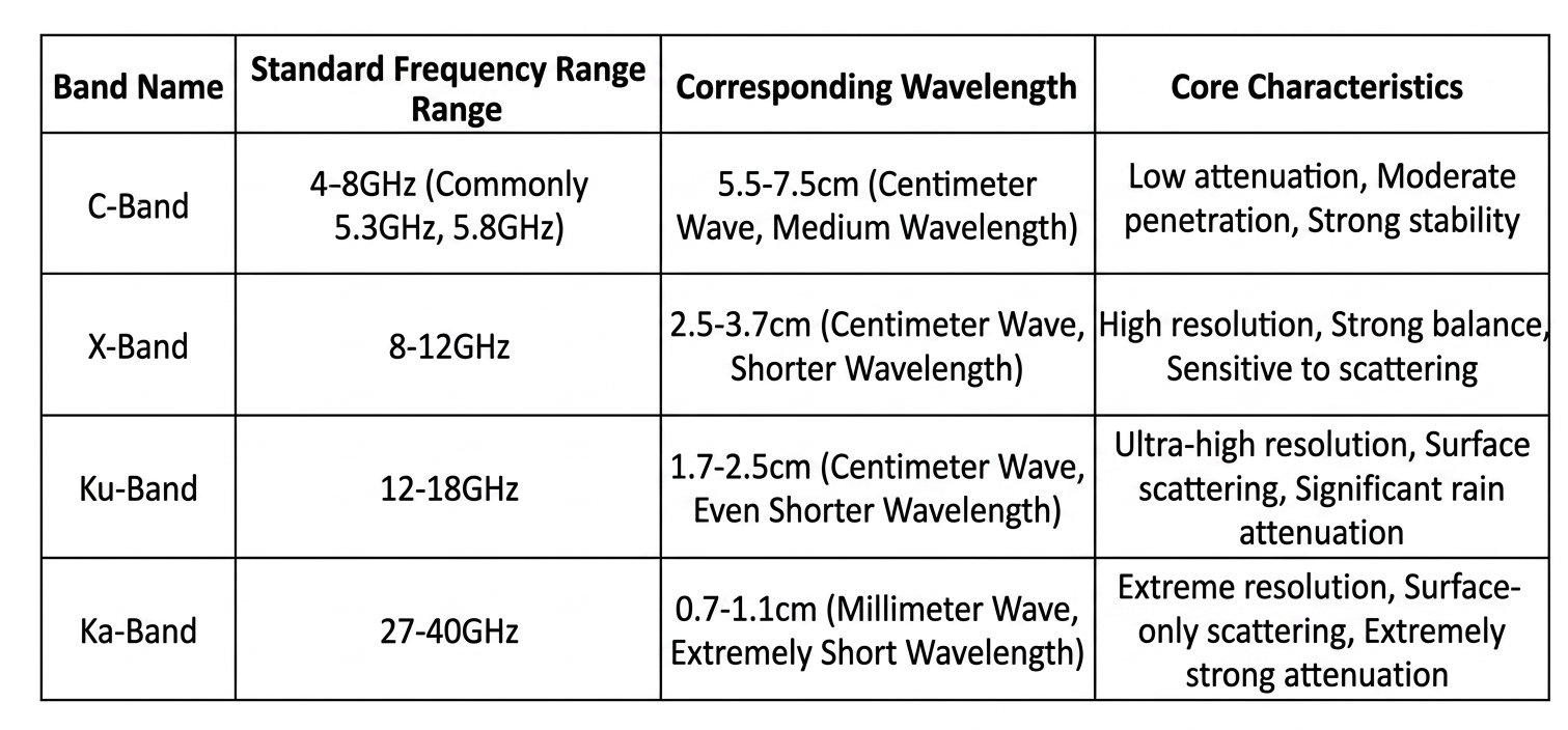
In short, the band positioning is as follows: C-band focuses on "broad spectrum stability", X-band focuses on "all-round balance", Ku-band focuses on "fine observation" and Ka-band focuses on "ultimate close-up". There is no absolute superiority or inferiority among the four types of bands, only differences in scene adaptation.
II. Core Influence Mechanisms of Different Frequency Bands on SAR Imaging Performance
The core evaluation indicators of SAR imaging performance include spatial resolution, ground feature detail reproduction, penetration capability, anti-interference capability, and image signal-to-noise ratio. The four frequency bands, through differences in wavelength and frequency, fundamentally affect these indicators, ultimately resulting in drastically different image quality and application value.
(I) Spatial Resolution and Ground Feature Detail Reproduction Capability
The theoretical resolution of SAR is determined by parameters such as signal bandwidth and slant range. However, the actual visual resolution and detail recognition of imaging are highly dependent on wavelength characteristics. The shorter the wavelength, the more sensitive the scattering response to the small structures, edge contours, and texture features of ground features, resulting in a sharper image and stronger small target recognition capability.
• C-band: With a longer wavelength, the ground feature scattering response is relatively smooth, resulting in a softer overall image with clear outlines, but weaker detail representation. It lacks sufficient differentiation of small ground features (such as small vehicles, small buildings, and surface cracks), making it suitable for large-area macroscopic imaging but not for fine-grained target recognition.
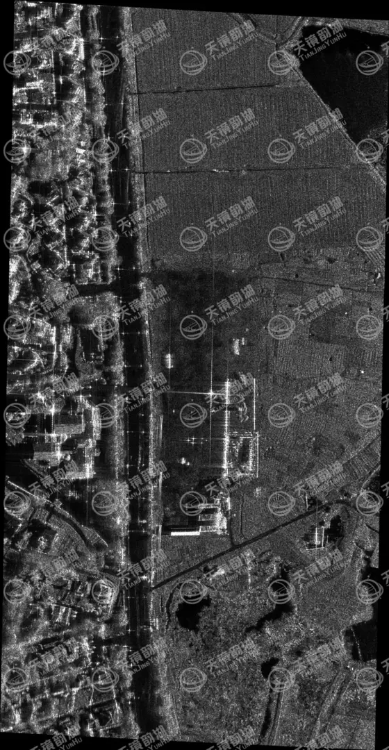
Imaging image of our company's C-band SAR product
• X-band: With a moderate wavelength, it achieves a golden balance between scattering sensitivity and resolution. It can cover large areas for observation and clearly reproduce details such as houses, roads, vehicles, and small and medium-sized water conservancy facilities. The ground features are clearly layered and have sharp edges and contours. It is the optimal choice that takes into account both macroscopic and microscopic aspects, and the visual imaging effect is most in line with the public's perception of high-definition remote sensing.
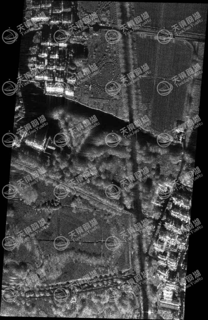
Our X-band SAR product imaging images
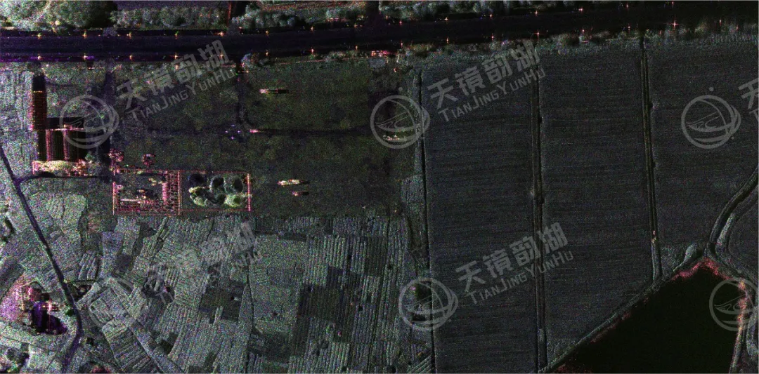
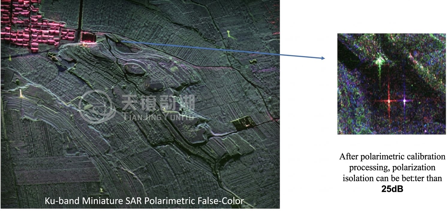
• Ku-band: Shorter wavelength, significantly improved spatial resolution, capable of capturing millimeter-level surface textures, fine building structures, small camouflaged targets, and detailed features of ships. The imaging image is full of detail, suitable for high-precision fixed-point observation, but the image is prone to local over-sharp noise, requiring higher signal processing.
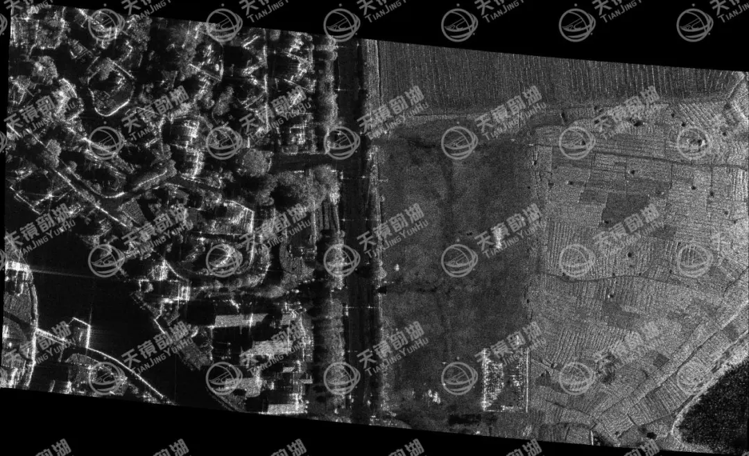
Our company's KU-band SAR product imaging image
• Ka-band: Extremely short wavelength, with sub-meter or even centimeter-level extreme resolution, enabling "close-up" imaging. It can identify ultra-small targets such as small ground equipment, subtle surface deformations, and building damage gaps. However, the imaging swath is extremely narrow and is highly susceptible to environmental interference, making it only suitable for short-range airborne or ground-based SAR systems.
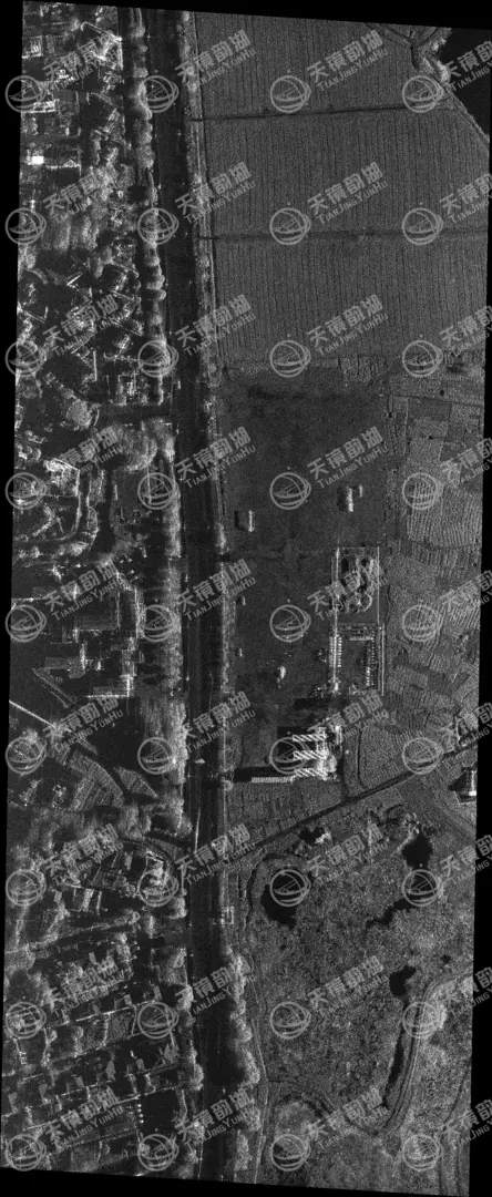
我司KA 波段SAR产品成像图
(二)地表穿透能力差异
微波穿透能力与波长呈正相关,波长越长,绕射能力越强,越能穿透浅层植被、干土、积雪等介质,捕捉地表以下或植被覆盖下的目标信息;波长越短,能量越集中于地物表层,几乎无穿透能力,仅反映地表最外层散射特征。
•C波段:穿透能力最优,可轻度穿透茂密树冠、浅层干土、薄积雪,能有效监测林下地形、地表浅层形变、冻土变化、裸土结构,规避植被遮挡带来的观测盲区,在林业、地质、农业监测中优势突出。
•X波段:穿透能力较弱,仅能穿透稀疏植被,无法穿透茂密树冠与土层,成像结果完全反映地表表层信息,适合城市、裸地、硬化路面、海洋等无遮挡场景观测。
•Ku/Ka波段:几乎无穿透性,微波能量全部被地物表层反射,叶片、墙面、土壤表层的细微散射都会被捕捉,完全无法获取下层信息,仅适用于纯表层目标观测,一旦有植被或薄土覆盖,目标信息会完全丢失。
(三)环境适应性与图像稳定性
SAR的核心优势是全天候观测,而频段直接决定其抗气象干扰能力,频率越高,水汽、雨滴、雾滴对微波信号的吸收与散射作用越强,信号衰减越严重,成像信噪比越低,画面易出现模糊、噪点、断层。
•C波段:大气穿透性最强,不受云层、大雾、小雨、沙尘影响,无论阴雨天气还是复杂气象条件,都能获取清晰、稳定的成像数据,是星载大范围组网观测的首选频段,真正实现全天时、全天候作业。
•X波段:环境适应性较强,常规云雾、小雨、阴天对成像无明显影响,仅在强降雨、特大暴雪天气下,信号会出现轻微衰减,图像质量小幅下降,整体稳定性接近C波段,适配绝大多数常规观测场景。
•Ku波段:环境适应性较差,降雨天气下信号衰减明显,雨滴散射会导致成像画面出现大量噪点,目标轮廓模糊,大雾、高湿度环境也会影响成像质量,仅适合在晴空或少云天气下开展精细化观测。
•Ka波段:环境适应性极差,属于“晴空专用”频段,轻微降雨、雾气、空气湿度偏大都会导致信号严重衰减,甚至无法形成有效成像,仅适用于近距离机载、地面固定站等可控环境下的高精度观测。
(四)成像幅宽与观测效率
波长与成像幅宽、观测效率呈负相关,波长越长,成像幅宽越大,单次过境覆盖范围越广,观测效率越高;波长越短,成像幅宽越窄,单次覆盖范围越小,更适合定点聚焦观测。
C波段成像幅宽最大,适合全国性、大区域国土普查、海洋监管、灾害全域排查;X波段幅宽适中,兼顾覆盖范围与分辨率,适配区域级常态化监测;Ku与Ka波段幅宽极窄,观测效率低,无法满足大范围普查需求,仅针对重点区域、特定目标做高精度特写观测。
三、分波段典型应用场景与选型策略
结合四大波段的成像效果与特性差异,不同场景下的SAR载荷频段选择需精准适配,避免盲目追求高分辨率而忽视实用性,以下是各波段核心应用场景与选型建议:
(一)C波段:全域普查、全天候监测首选
核心适配场景:星载大范围国土测绘、洪涝/地震/滑坡等全域灾害监测、海洋洋流与海冰监测、农林资源普查、冻土与地表形变长期监测、林业资源调查(林下目标观测)。
选型逻辑:需要大范围覆盖、长期稳定监测、穿透植被遮挡、不受复杂气象干扰的场景,优先选择C波段,代表项目包括全球主流商用SAR卫星组网、国家级地质灾害监测预警系统。
(二)X波段:全能通用、军民两用核心
核心适配场景:区域级高精度测绘、城市规划与违建监测、水利设施巡检、交通道路监测、中小型灾害定点核查、军事侦察、海洋舰船监管、农业精细管理。
选型逻辑:需要兼顾分辨率、覆盖范围、环境适应性,既满足宏观监测,又能识别中小型地物目标的通用场景,X波段是性价比最高、应用最广泛的选择,也是机载SAR与高分辨率星载SAR的主流频段。
(三)Ku波段:重点区域精细观测专用
核心适配场景:重点工程结构形变监测、建筑细微破损识别、小型军事目标侦察、港口舰船精细监管、地表微小裂缝监测、高精度局部测绘。
选型逻辑:针对固定重点区域,需要超高分辨率、捕捉细微地表变化,且可提前规避恶劣天气开展观测的场景,选用Ku波段,多用于机载高精度SAR载荷与专用侦察载荷。
(四)Ka波段:极致特写、近距高精度观测
核心适配场景:近距离地面目标精细识别、机载近距离侦察、工业设施细微形变监测、小型目标特征提取、实验室级高精度成像验证。
选型逻辑:仅适用于近距离、晴空环境下,需要厘米级极致分辨率的特殊场景,不适合大范围、远距离、全天候作业,属于特种专用频段。
四、SAR载荷频段选型总结与工程建议
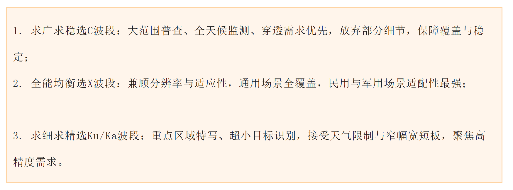
SAR频段没有绝对的“最优解”,核心是匹配应用场景需求,四大波段的选型可总结为三大核心原则:
(一)典型场景推荐
农业与林业监测:优先选用C波段,兼顾冠层穿透与散射信息丰富度;X波段可用于作物参数高精度反演。
地形测绘与地质灾害监测:X波段在星载干涉测量中应用广泛,分辨率与形变监测精度均表现优异;C波段适合大范围、长时序地表形变监测。
海洋监测与海冰观测:C波段是海洋SAR的经典选择,对海面风场、海浪谱反演效果稳定。
目标识别与精细侦察:Ka波段适用于高分辨率目标识别,常在无人机或临近空间平台搭载;Ku波段则在分辨率与平台适应性之间取得良好平衡,适合中小型无人机任务。
穿透式测绘与考古探测:C波段因穿透性较优,在干旱区浅层地表探测中具有独特价。
在实际工程设计中,针对复杂应用需求,可采用多频段融合设计,比如C+X波段组合,兼顾大范围普查与定点精细化观测,弥补单一频段的短板,实现全域与细节、稳定与高精度的双重兼顾。
五、机载微型SAR系统