

When you stand on the ground, you can see the outlines of trees; climb a tall building, and you can observe the layout of an entire street; if you take an airplane, you can overlook the entire city. This change in perspective brings about a revolution in cognition. Synthetic Aperture Radar (SAR) technology is precisely the "eye in the sky" for humankind to perceive the world. It is not limited by day or night or weather, penetrates clouds and fog, and can even "touch" subtle changes on the Earth's surface, giving us unprecedented observation capabilities.
In this unseen realm of perception, spaceborne, airborne, and ground-based SAR constitute a three-dimensional observation network from space to the ground. While sharing common principles, they each possess unique strengths, collectively weaving a sophisticated global sensing network.
SAR: A Remote Sensing Revolution of "Active Touch"
Unlike traditional optical remote sensing's "seeing" approach, SAR is an "active touch" sensing technology. It emits microwave signals and receives the echoes from the interaction of these signals with targets. Through complex signal processing, it forms high-resolution images.
The core appeal of SAR lies in its "synthetic aperture" (SAR) technology. By moving the platform, SAR virtualizes a small real antenna into a large antenna, achieving high-resolution imaging. This technology gives SAR many unique advantages: it is unaffected by day or night, can penetrate clouds, fog, rain, snow, and vegetation, is extremely sensitive to minute changes on the Earth's surface, and can even "see" structures at certain depths underground.
I. Spaceborne SAR: A "Space Eye" Overlooking Earth
Spaceborne SAR, simply put, is a remote sensing device that carries a SAR system on an artificial Earth satellite to observe the Earth's surface from space. It acts like an "eye" suspended in space, capable of monitoring changes on Earth over a wide area over long periods and continuously.
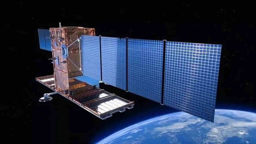
(1) System Composition: The spaceborne SAR system mainly consists of an antenna, transmitter, receiver, signal processor, and data storage and transmission equipment.
(2) Working Principle: Microwave signals of a specific frequency are transmitted to the Earth's surface via the antenna. These signals are reflected when they encounter objects on the Earth's surface, and the reflected signals are received by the receiver. Because the satellite is constantly moving in space, it forms a virtual "large antenna" (i.e., synthetic aperture). By processing and synthesizing the signals received from different locations, high-resolution ground images can be obtained.
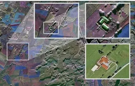
(3) Technical characteristics: a. Wide observation range: A single spaceborne SAR satellite can cover a width of hundreds of kilometers, enabling observation of large areas in a short period of time.
b. Long observation period: It can perform long-term dynamic monitoring of the same area, helping scientists study long-term trends in Earth's surface changes.
c. Relatively low spatial resolution: Generally between a few meters and tens of meters, which is insufficient to meet the needs of detailed observation of small-scale targets.
II. Airborne SAR: Flexible and Mobile "Aerial Detectives"
Airborne SAR is a remote sensing device that installs a SAR system on an aircraft, enabling observation of the Earth's surface through flight. Compared to spaceborne SAR, airborne SAR offers greater flexibility and mobility, allowing for adjustments to the observation area and parameters as needed.
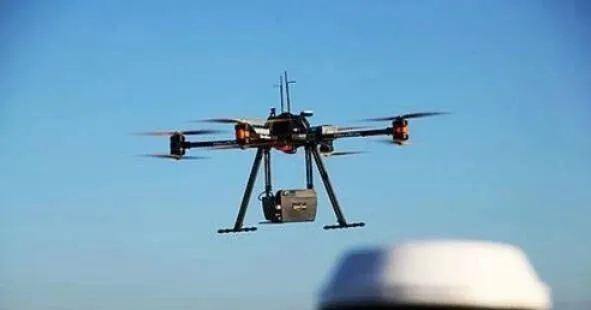
(1) System Composition: The system includes an antenna, transmitter, receiver, signal processor, and data storage and transmission equipment. However, due to limited payload and space, the airborne SAR system is relatively small in size and weight, resulting in a more compact structure.
(2) Working Principle: Ground images are acquired by transmitting and receiving microwave signals. While the aircraft is in flight, the SAR antenna continuously transmits microwave signals to the ground, which are then reflected by the ground and received by the receiver.
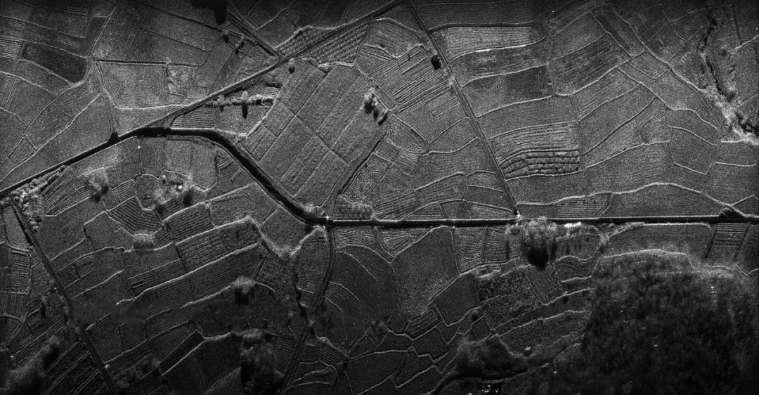
(3) Technical Characteristics: a. Flexibility and Maneuverability: The aircraft can reach the designated observation area in a short time and can flexibly adjust the imaging parameters of the SAR system according to the size, shape, and location of the observed target.
b. High Resolution: It can achieve meter-level or even sub-meter-level resolution, enabling fine observation of small-scale targets.
c. Low Endurance: The observation time and area of a single flight are limited, making it difficult to conduct long-term continuous observation of large areas.
III. Ground-Based SAR: The "Ground Sentinel" for Fixed-Point Monitoring
Ground-based SAR is a remote sensing device that fixes the SAR system on the ground to conduct fixed-point, continuous observation of a specific area. It acts like a "ground sentinel," constantly protecting the safety of the monitored area and promptly detecting minute changes within the monitored area.
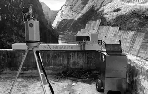
(1) System composition: Mainly composed of antenna, transmitter, receiver, signal processor, data storage device and power supply equipment.
(2) Working principle: Microwave signals are emitted to the monitoring area through the antenna. After the signal encounters the monitoring target, it is reflected back and received by the receiver. Ground-based SAR is fixed on the ground, and the observation position is relatively fixed, so it can conduct long-term continuous observation of the same monitoring area and obtain dynamic change information of the monitoring target.
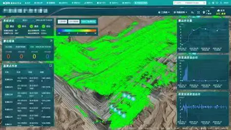
(3) Technical Characteristics:
a. High Resolution: Ground-based SAR is located relatively close to the monitored target, typically between several kilometers and tens of kilometers, thus achieving extremely high spatial resolution, usually reaching centimeter or even millimeter levels, enabling clear observation of minute changes in the monitored target.
b. High Sensitivity: It can detect minute displacements and deformations of the monitored target, which is of great significance for the safety monitoring of large engineering structures and early warning of geological disasters.
c. Limited Observation Range: It can only observe an area within a certain angle range centered on the antenna, unlike spaceborne SAR and airborne SAR which can perform large-scale observations.
IV. A Trio: A Collaborative Sensing Network
Spaceborne, airborne, and ground-based SAR are not substitutes for each other, but rather form a complementary, three-dimensional observation network.
Spaceborne SAR provides global context and long-term trends, acting as strategic command to grasp the big picture; airborne SAR provides detailed regional information and emergency response, acting as a tactical expert to solve local problems; ground-based SAR provides precise point-based data and process monitoring, acting as a sentinel to focus on details. The three work together to form a complete observation chain from global to regional to single-point.
In terms of application scenarios, spaceborne SAR is suitable for global-scale environmental monitoring and ocean monitoring; airborne SAR is suitable for disaster emergency response, urban planning, and forestry surveys; ground-based SAR is suitable for large-scale engineering structure safety monitoring, geological disaster early warning, and mining monitoring.
V. The Future: A Smarter, More Integrated Sensing Era
SAR technology is developing towards higher resolution, shorter revisit cycles, and stronger information extraction capabilities. The new concept satellite constellation plan will achieve hourly revisits globally; the introduction of artificial intelligence technology is making SAR image interpretation more intelligent and efficient; and the fusion with data from other sensors is giving rise to richer Earth observation products.
China's SAR technology is also developing rapidly. The Gaofen-3 series satellites have achieved operational observation capabilities, and several new SAR satellites are under planning and development. Airborne and ground-based SAR systems are also being applied in many fields, providing important technical support for national economic construction, disaster prevention and mitigation, and national security.
In short, spaceborne SAR, airborne SAR, and ground-based SAR, as important components of SAR technology, each have unique performance and application value. They cooperate and complement each other in different fields, jointly providing strong technical support for humanity to understand, protect, and utilize the Earth. With the continuous development and innovation of SAR technology, it is believed that they will play an even more important role in the future and make a greater contribution to the sustainable development of human society.
VI. Company Introduction
Our company, with years of R&D experience and professional technical accumulation, has successfully launched multiple series of airborne SAR products equipped with multiple bands and possessing multiple capabilities. Currently, it has coverage of multiple bands including X, Ku, K, Ka, C, W, and L, and can achieve strip imaging, spotlight imaging, single polarization mode, full polarization mode, and interferometric mode.








