

I. Overview of InSAR Technology
Interferometric Synthetic Aperture Radar (InSAR) technology is a space-based Earth observation technique based on multiple interferometric images of the same area from synthetic aperture radar (SAR), combined with signal processing and geodetic principles, to achieve high-precision inversion of the three-dimensional deformation field and topographic information of the Earth's surface. Its core advantages lie in its wide coverage, high spatial resolution, and all-weather, all-time observation capabilities, overcoming the limitations of traditional ground monitoring methods (such as GPS and leveling) in terms of coverage and efficiency. Deformation monitoring accuracy can reach the millimeter to centimeter level.
InSAR technology has undergone iterations from Differential Interferometry (D-InSAR) to Multi-Temporal Interferometry (MT-InSAR, including PS-InSAR, SBAS-InSAR, etc.), gradually solving problems such as decoherence, atmospheric errors, and topographic residuals. It has been widely applied in urban areas, mines, earthquake monitoring, volcano monitoring, glacier monitoring, permafrost monitoring, landslide monitoring, and infrastructure, providing crucial data support for geological disaster prevention, ecological protection, and engineering safety assessment.
II. Core Application Areas and Monitoring Key Points
(I) Urban Subsidence Monitoring
Urban subsidence is the vertical downward displacement of the earth's surface caused by natural or anthropogenic factors during the urbanization process. Over the long term, it damages underground pipelines, buildings, and roads, threatening urban safety.
1. Main Causes of Subsidence
The core cause is human factors, with groundwater extraction being the primary reason: Excessive groundwater extraction due to population and industrial development in large cities like Shanghai and Beijing has led to the compression of aquifers and caused surface subsidence—in Shanghai at the end of the 20th century, some areas experienced annual subsidence exceeding 100mm, and multiple subsidence funnels formed in the Beijing plains, with cumulative subsidence exceeding 2m; in addition, the consolidation of natural soil layers in soft soil distribution areas (such as the Yangtze River Delta and Pearl River Delta) also causes slow subsidence, but the rate is much lower than that caused by anthropogenic factors.
2. Core Challenges in Monitoring
• **Difficulty in Phase Unwrapping:** In high-resolution SAR imagery, dense urban high-rise buildings cause overlapping and broken interference fringes, directly affecting the accuracy of phase unwrapping and distorting deformation results.
• **DEM Residual Interference:** Low-resolution external digital elevation models (DEMs) (e.g., SRTM 30m DEM) cannot characterize urban micro-topography, and residual topographic phase interference hinders settlement signal extraction, with a more significant impact in urban-rural fringe areas.
• **Inapplicability of Linear Assumption:** MT-InSAR technology assumes linear deformation (constant rate) at PS/DS points. However, groundwater recharge and construction in cities can lead to non-linear settlement (e.g., short-term acceleration, rebound), easily causing misjudgments of deformation information.
(II) Mine Deformation Monitoring
Mining alters the underground rock structure, causing surface subsidence and cracking, resulting in "mined-out subsidence," threatening production safety and damaging the ecosystem. InSAR technology focuses on a dual-core approach of "deformation monitoring - trend prediction."
1. Core Monitoring Content
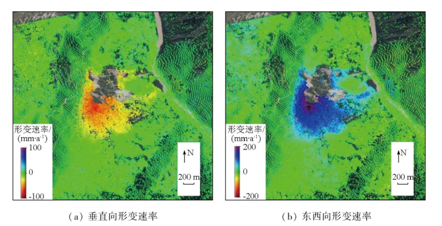
• Three-dimensional surface deformation monitoring in the mining area: By fusing multi-track SAR data (ascending/descending orbits, different incident angles) and combining GPS calibration, the three-dimensional deformation fields in the eastward, northward, and vertical directions are inverted to locate the subsidence center, boundary, and displacement gradient of the goaf, supporting the stability assessment of the goaf;
• Deformation trend prediction: Based on 1-3 years of MT-InSAR monitoring data, combined with coal seam depth, lithology, and mining progress, models such as grey prediction (GM(1,1)) and BP neural network are used to predict the deformation trend for the next few months to several years, identifying high-risk areas in advance.
2. Major Technical Challenges
**Prominent Incoherence Issues:** Deformation in mining areas is characterized by "small range (several to tens of square kilometers) and large gradient (centimeter-level on a daily basis)," far exceeding the InSAR phase entanglement threshold. This leads to a sharp drop in coherence, even approaching zero, at the boundaries of goaf and fracture areas, making it impossible to obtain effective phase data.
**Limited Application Scenarios:** Current technologies focus on "monitoring and prediction," providing insufficient support for the analysis of mining area subsidence mechanisms (such as changes in rock mass stress and correlations with filling effects) and ecological restoration (land reclamation, vegetation restoration). Data is not deeply integrated with ecological information.
(III) Seismic Deformation Monitoring
Seismic deformation is classified into three categories: coseismic (during an earthquake), post-earthquake (stress redistribution), and inter-earthquake (stress accumulation). InSAR technology provides crucial data for earthquake mechanism research and risk assessment.
1. Core Monitoring Content
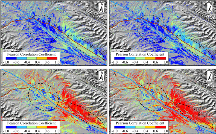
• Coseismic Deformation Monitoring: Coseismic deformation is large in magnitude (up to the meter level, such as the Wenchuan earthquake and the Tohoku earthquake in Japan). InSAR can quickly acquire the line-of-sight (LOS) deformation field and identify fault strike and rupture length. However, due to limitations in side-view imaging, it cannot directly invert 3D deformation and requires multi-track or GPS fusion. Furthermore, large near-field deformation easily leads to decoherence, affecting the accuracy of fault parameters.
• Post-earthquake/Inter-earthquake Deformation Monitoring: Both are small in magnitude (millimeters/year). MT-InSAR technology is needed to suppress temporal decoherence (seasonal vegetation changes) and atmospheric errors. It has already been applied to the San Andreas Fault Zone in the United States, the North Anatolian Fault Zone in Turkey, and the Haiyuan Fault Zone and Xianshuihe Fault Zone in China, supporting earthquake period analysis. 2. Technology Optimization Directions
The accuracy of 3D deformation needs to be improved through multi-source data fusion (InSAR + GPS + optical remote sensing), while high-resolution SAR data (Sentinel-1A/B 3m, TerraSAR-X 1m) should be used to reduce the impact of near-field incoherence.
(IV) Volcanic Activity Monitoring
Volcanic surface deformation (uplift/subsidence) is a precursor to eruption. InSAR technology focuses on "early warning - mechanism analysis" to support volcanic risk prevention and control. 1. Core Monitoring Objectives
• Early Eruption Warning: Utilizing high-frequency SAR data (such as Sentinel-1 with 12-day revisit) to capture surface uplift (centimeter to meter scale) caused by the filling of underground magma chambers, identifying eruption risks weeks to months in advance (e.g., the 2018 Kilauea eruption warning in Hawaii);
• Magma Chamber Parameter Inversion: Combining InSAR deformation fields with physical models such as the Mogi model, inverting the location, depth, and volume change rate of magma chambers to determine the intensity of volcanic activity;
• Topographical Influence Correction: Volcanic areas (cones, lava flow plateaus) have complex topography, requiring high-resolution DEMs (such as ALOS World 3D 12.5m DEM) to correct geometric distortions and reduce errors caused by the angle between the line of sight and the deformation direction.
2. Application Limitations
Volcanic ash and water vapor reduce the coherence of SAR images, making it difficult to obtain effective data during periods of active eruption. SAR data coverage frequency for remote volcanoes (Antarctica, Pacific islands) is low (30-day repetition cycle), failing to meet high-frequency monitoring requirements.
(V) Infrastructure Deformation Monitoring
Infrastructure (bridges, tunnels, highways, transmission towers, tailings dams) is affected by surrounding surface deformation. Damaged foundation stability can lead to structural collapse. InSAR needs to address both "large-scale - high-resolution" monitoring requirements.
1. Monitoring Objects and Requirements
• Linear Facilities (Bridges, Highways): Monitor settlement and lateral displacement along the route, focusing on piers and roadbeds;
• Point Facilities (Transmission Towers): Monitor vertical settlement and tilting of the tower foundation;
• Area Facilities (Tailings Dams): Monitor overall dam settlement, displacement, and cracks to prevent collapse.
2. Major Technical Challenges
Traditional SAR sensors have small antenna areas and low resolution (such as the early ENVISAT25m), which cannot meet the needs of localized, high-resolution monitoring of infrastructure. Furthermore, the coverage of a single track is limited, and large-scale monitoring requires image stitching, increasing the risk of error accumulation. In addition, vegetation and water bodies around facilities reduce coherence, and metal structures are prone to generating false phases, interfering with deformation identification.
(VI) Glacier Movement Monitoring
Glaciers are indicators of climate change; their movement and mass balance reflect regional climate conditions. InSAR, with its advantages of "penetrating ice and snow and operating in all weather conditions," compensates for the limitations of optical remote sensing (which is affected by clouds, fog, and snow cover).
1. Core Monitoring Content
• Glacier Boundary Extraction: The fluidity of ice and snow on the glacier surface results in low SAR coherence, contrasting with the high coherence of the surrounding bare rock and vegetation. This allows for precise delineation of glacier tongues and cirques, suitable for high-altitude, foggy regions (such as Himalayan glaciers);
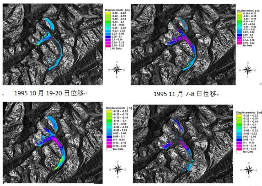
• Glacier Flow Velocity Monitoring: Phase changes over intervals of several days to several months are calculated using D-InSAR technology to invert the LOS-directed flow velocity. Multi-track fusion is then used to obtain two-dimensional planar flow velocities (accuracy: meters/year in polar regions, centimeters/day in the Alps);
• Glacier Thickness Change Monitoring: The thickness change rate is calculated based on 5-10 years of InSAR elevation data (combined with DEM differential). Surface ice and snow thickness is compared and inverted using different wavelength SAR (L/C bands) to support mass balance studies.
2. Technical Characteristics
Advantages include being unaffected by the optical contrast limitations of ice and snow, and the ability to penetrate dry snow (several meters deep); limitations include the absorption of SAR signals by wet snow, leading to decreased monitoring accuracy during the summer melting period; and the tendency for phase entanglement to occur in high-velocity glaciers (over 1 km/year), requiring high revisit rate data optimization for untangling.
(VII) Permafrost Process Monitoring
Permafrost (temperature < 0℃ containing ice-rock soil) is widely distributed in high-latitude (Arctic, Siberia) and high-altitude (Tibetan Plateau) regions. Climate warming and human activities (oil and gas extraction, road construction) are causing its degradation, leading to ecological and engineering problems.
1. Impacts of Permafrost Degradation
• Ecological Level: Permafrost thawing loosens the soil, leading to soil erosion (such as gully erosion on the Qinghai-Tibet Plateau), damaging alpine meadows and coniferous forests, and causing grassland degradation and desertification.
• Engineering Level: Infrastructure in permafrost regions (Qinghai-Tibet Railway, China-Russia crude oil pipeline) relies on permafrost stability. Freeze-thaw cycles cause foundation settlement and uneven deformation, leading to road cracking and pipeline rupture.
2. Characteristics of InSAR Monitoring
Permafrost deformation exhibits a "seasonal-slow" pattern: freezing and uplift in winter, thawing and subsidence in summer, with annual amplitudes on the order of centimeters. MT-InSAR technology (such as PS-InSAR) extracts seasonal deformation and long-term degradation trends from 1-3 years of data, identifying degradation hotspots (along engineering routes, areas of significant climate warming). It is currently applied in regions such as the Qinghai-Tibet Plateau and the Arctic, but summer vegetation (alpine meadows) can cause temporal incoherence, requiring optimization of the PS point extraction algorithm.
(VIII) Landslide Monitoring
Landslides are sudden disasters caused by the sliding of soil and rock along weak surfaces, resulting in significant destructive power. InSAR technology is used for hazard identification and dynamic monitoring, but its application is limited by technical adaptability and environmental interference.
1. Limitations of Core Technologies
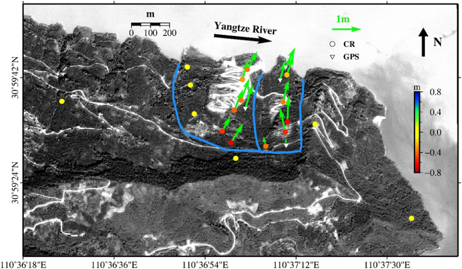
• Insufficient adaptability of MT-InSAR: Existing technologies are based on ground subsidence and assume linear deformation, while landslides exhibit nonlinearity (early-stage millimeter/monthly creep, later-stage centimeter/day acceleration). Linear models cannot capture the acceleration phase, easily missing early warning windows; furthermore, landslide bodies are loose soil and rock, making it difficult to extract sufficient PS/DS points, resulting in low data coverage.
• Topographic and vegetation interference: Landslides often occur in mountainous areas. SAR image overlay and shadows cause some areas to lack effective phase; dense vegetation in mountainous areas (especially during the rainy season) causes temporal incoherence, sometimes making monitoring results impossible.
2. Optimization Directions
It is necessary to develop nonlinear deformation MT-InSAR algorithms (such as Kalman filter dynamic models), integrate LiDAR (for terrain correction) and optical remote sensing (for boundary identification), and use high-resolution, high-revisit-rate SAR data (Sentinel-1A/B, Gaofen-3) to improve the monitoring accuracy of small-scale, high-risk landslides.
III. Development Trends of InSAR Deformation Monitoring Technology
Addressing current technological bottlenecks, future breakthroughs will focus on "high precision, wide coverage, intelligence, and multi-scenario applications":
(I) High-Resolution, High-Revisit-Rate Satellite Applications
Satellites such as the European Sentinel-1 constellation (6-day revisit), China's Gaofen-3 (1m resolution), and the US NISAR (L/C dual-band, 12-day revisit) will solve the problems of "balancing large-scale coverage with high precision" and "high-gradient deformation incoherence," supporting the monitoring of small-scale disasters such as small landslides and localized mine subsidence.
(II) Deepening Multi-Source Data Fusion
InSAR will be deeply integrated with GPS (calibrating 3D deformation), LiDAR (correcting topographic distortion), optical remote sensing (aiding coherence analysis), and geological/meteorological data (quantifying the impact of structure/climate on deformation), improving monitoring accuracy and mechanism interpretation capabilities.
(III) Intelligent Data Processing
Utilizing AI algorithms (CNN, RNN) to automate the screening of highly coherent scatterers and phase unwrapping, shortening the processing cycle (from days to hours); constructing an AI-based early warning model for deformation anomalies to automatically identify risk areas and push early warning information, improving decision-making efficiency.
(IV) Expansion into Emerging Scenarios
Extending its application to areas such as sea-level rise monitoring (distinguishing between absolute sea-level rise and land subsidence), agricultural water resource monitoring (inverting soil moisture content), and carbon neutrality monitoring (assisting in ecological carbon sink assessment), expanding the technology's application value.
IV. Conclusion
InSAR deformation monitoring technology has been widely applied in eight major fields, providing irreplaceable high-precision support for geological disaster prevention, ecological protection, and engineering safety. However, it still faces challenges such as incoherence, phase unwrapping, and model adaptability. With the development of high-resolution satellites, multi-source fusion, and intelligent technologies, InSAR will further overcome bottlenecks and play a greater role in areas such as smart disaster prevention, ecological civilization construction, and major engineering safety, providing key technological support for addressing global environmental change and disaster risks.








