

1. Explain Ku-band SAR
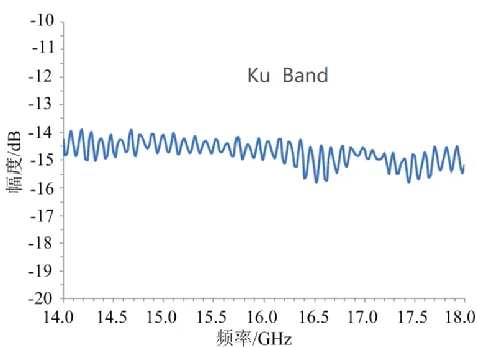
Synthetic Aperture Radar (SAR) bands are typically defined based on the frequency (or wavelength) of electromagnetic waves, with different bands corresponding to different frequency ranges and application characteristics. The Ku band, as an important member of this family, has a frequency range defined between 12-18 GHz, corresponding to wavelengths of approximately 1.67-2.5 cm. From the perspective of the overall band family, the Ku band occupies a special position within the microwave frequency band. It is lower than the higher-frequency Ka band (26.5-40 GHz) and higher than the relatively lower-frequency X band (8-12 GHz) and C band (4-8 GHz), etc.
2. Advantages of Ku-band SAR
(1) High-resolution imaging capability
Due to the short wavelength of the Ku band (1.67-2.5 cm), according to the radar resolution formula, under the same antenna size and platform parameters, the shorter the wavelength, the higher the spatial resolution that the radar system can achieve. Therefore, Ku-band SAR can acquire high-resolution images from centimeter to sub-meter level, and can clearly distinguish small targets on the ground, such as building details, road markings, and small vehicles. This high-resolution characteristic makes it of great application value in fields such as urban planning, precision agriculture, target detection and recognition.
(2) Moderate Penetration Ability
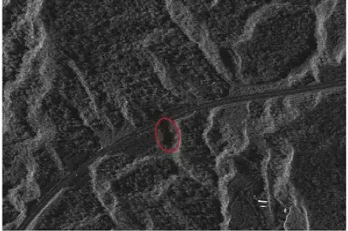
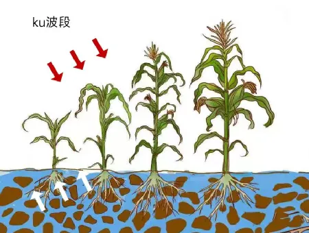
Compared to the high-frequency Ka band, the Ku band electromagnetic waves have stronger penetration ability. They can penetrate atmospheric media such as clouds, fog, and light rain of a certain thickness, and also have some penetration ability through vegetation and soil surface. However, Ku band electromagnetic waves can hardly penetrate vegetation canopies and most ground features. They primarily interact with the surface of the target. Therefore, it is not suitable for forestry biomass estimation or underground exploration. However, in the agricultural field, Ku band SAR can penetrate crop canopies to obtain information such as crop growth status and soil moisture.
(3) Target Recognition and Classification Performance
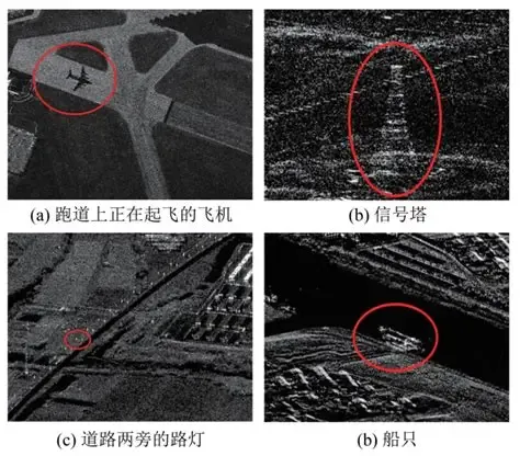
The shorter wavelength makes Ku-band SAR highly sensitive to minute deformations, vibrations, and subtle surface textures (such as leaves and building details) of targets. This makes it excellent in target recognition and vibration measurement. Different types of ground features (such as metal, concrete, vegetation, and water bodies) exhibit significant differences in their reflection coefficients and scattering patterns to Ku-band electromagnetic waves. These differences manifest as different grayscale values and texture features in radar images. By extracting and analyzing these features, combined with appropriate image processing algorithms, targets can be accurately identified and classified.
(4)Strong anti-interference ability
The Ku band has a higher frequency and is relatively less affected by low-frequency interference signals in nature (such as lightning, industrial electromagnetic radiation, etc.). At the same time, due to its short wavelength and relatively small antenna size, it is easy to achieve narrow-beam emission, and can concentrate electromagnetic wave energy in a specific target area, reducing the impact of side lobe interference. In addition, Ku-band SAR usually uses advanced technologies such as pulse compression and coherent processing to further improve the anti-interference ability of the system, ensuring that it can still work stably in complex electromagnetic environments and obtain high-quality image data.
3. Main applications of Ku-band SAR
With its advantages of high resolution and target recognition, Ku-band SAR is widely used in both military and civilian fields:
(1) Military reconnaissance and target identification: used for high-resolution detailed inspection of battlefields and key facilities. It can identify vehicles, aircraft, and even determine vehicle types. Its sensitivity to moving targets also helps detect moving vehicles or rotating radar antennas.
(2) Urban mapping and change detection: It can generate three-dimensional urban maps with a resolution of 0.1 to 0.5 meters, which can be used for urban planning, illegal building monitoring, disaster assessment, etc.
(3) Fine terrain surveying and mapping: Mounted on an aircraft, it can conduct large-scale terrain map surveying and generate high-precision digital elevation models.
(4) Infrastructure inspection: Perform high-resolution imaging of power lines, bridges, dams, etc. to detect minor deformations or damage.
(5) Agricultural precision monitoring: Although it cannot penetrate the canopy, it can monitor crop height, ridge row structure, etc. with high resolution.
(6) Emergency rescue: After a disaster occurs, quickly obtain high-resolution radar images of the disaster area, regardless of weather and day and night, to assess building collapse, road damage, etc.
4. Summary
All in all, Ku-band SAR is a powerful tool in the SAR family that pursues "ultimate resolution" and "lightweight platform". It has made certain sacrifices in terms of penetration and all-weather capabilities, but it plays an irreplaceable role in the field of close-range and high-precision observation that it is good at. With the advancement of UAV technology and signal processing algorithms, the civilian prospects of Ku-band SAR will be broader.
5. Airborne micro SAR system
Suzhou Tianjing Yunhu Intelligent Technology Co., Ltd. (referred to as: Tianjing Yunhu) is committed to becoming the world's leading synthetic aperture radar solution provider, providing users with customized radar equipment, SAR data collection services, and radar data products. Tianjing Yunhu relies on years of R&D experience and professional technology accumulation to launch SAR products with multiple bands and frequency modulated continuous wave and pulse systems with multiple capabilities. At present, Tianjing Yunhu has coverage of multiple wavebands such as X, Ku, K, Ka, C, W, L, etc., and the product system has single polarization, full polarization, strip, bunching, interference, single pulse search and other modes. The product has real-time imaging, GMTI, deformation monitoring and other functions. Tianjing Yunhu SAR products can be equipped with multi-rotor/fixed-wing drones, manned aircraft, satellites and vehicle-mounted platforms.








