
Tianjing Yunhu | L-band pulse SAR unlocks new possibilities for remote sensing in complex environments

Browse: 103 Time: 2026-02-13

In the fields of remote sensing and high-precision imaging, synthetic aperture radar (SAR) has become an indispensable technical means for modern Earth observation due to its all-weather and all-day operation capabilities. L-band pulse SAR, with its strong penetration, all-weather and high-resolution characteristics, has become the preferred solution for information acquisition in complex environments.

Our company has launched the XY1A-L miniature synthetic aperture radar system, which breaks through the limitations of traditional remote sensing with innovative technology, and provides highly reliable intelligent remote sensing solutions for multiple scenarios such as land surveying, marine monitoring, pipeline inspection, and camouflage assessment.

I. Onboard Real-Time Imaging

Full-flight onboard real-time imaging was achieved. During flight missions, radar echo data was rapidly processed by the onboard processing unit, and the generated high-definition images were transmitted back to the ground station in real time via data transmission links, truly achieving "seeing while flying, acquiring data instantly," which has irreplaceable value in scenarios such as emergency monitoring and dynamic target tracking.
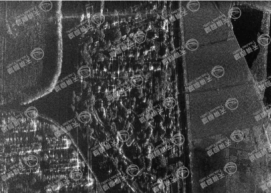
Real-time image at 0.5m onboard

II. Core Performance Advantages

The Xiangyun 1A-L is designed with an L-band pulse system as its core, featuring a center frequency of 1.2GHz and a bandwidth of 400MHz. Its low-frequency, long-wave characteristics endow it with superior penetration capabilities, allowing it to penetrate vegetation and soil to capture subsurface and internal vegetation structural information. The system supports both strip imaging and spotlight imaging modes, and has single-polarization and full-polarization acquisition capabilities. It integrates a high-precision POS system (IMU + differential GNSS) and combines a unique "intra-pulse motion compensation" and MD autofocus algorithm, providing polarization and radiometric calibration functions. This effectively suppresses image blurring, ensuring the output of clear, detailed, high-quality images under various flight conditions.

The system supports standard data and command interfaces, flexibly compatible with various UAV flight control and ground station systems. It also provides open APIs and SDKs, supporting secondary development and deep integration with industry software, facilitating customized functional expansion for different application scenarios (such as land surveying, pipeline inspection, marine monitoring, disaster assessment, etc.).
III. Flight Tests

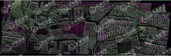
Our company conducted multiple test flights of the Xiangyun 1A-L product at our test site in Zhouzhuang, continuously updating and debugging it. Ultimately, our Xiangyun 1A-L product achieves an imaging resolution better than 0.5m, while keeping the overall weight under 8KG and power consumption below 150W. It possesses excellent vibration resistance, shock resistance, high and low temperature resistance, and moisture resistance, and can operate stably within a wide temperature range of -20℃ to 50℃, even adapting to high-altitude, low-pressure environments above 5500 meters, ensuring continuous and stable operation under various harsh conditions. It is perfectly compatible with various UAVs, including hexacopter and fixed-wing UAVs.

The system supports standard data and command interfaces, flexibly compatible with various UAV flight control and ground station systems. Simultaneously, it provides open APIs and SDKs, supporting users for secondary development and deep integration with industry software, facilitating customized functional expansion according to different application scenarios (such as land surveying, pipeline inspection, marine monitoring, disaster assessment, etc.).

Post-processing for high-precision imaging at 0.2m
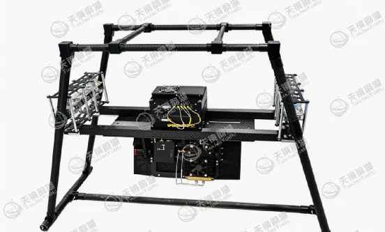
L-band SAR system architecture diagram
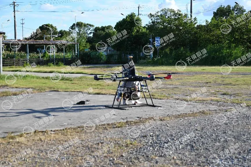
L-band SAR flight test image


Related Information

Related Information
2026.08.28

Tianjing Yunhu | MiniSAR: Full Polarimetric Imaging Capability

In the field of remote sensing today, synthetic aperture radar (SAR), visible light, and infrared together form a multi-layered observation system. Visible light remote sensing is intuitive and clear, while infrared remote sensing excels at thermal sensing. However, both are passive detection methods, heavily reliant on sunlight or the target's own thermal radiation. Once they encounter cloud cover, nightfall, or rainy/foggy weather, their detection capabilities are significantly reduced or even completely lost.
2026.08.26

Tianjing Yunhu | P-band Airborne SAR Radar System

Low-frequency radars (such as P-band and L-band radars) can "see farther and see more clearly" because of their longer wavelengths, lower attenuation, and reduced sensitivity to stealth coatings. In modern air defense systems, they are key to anti-stealth radars. They can penetrate 1-meter-thick camouflage netting and 3-meter-thick bushes to identify hidden tanks and radar stations, and are less likely to trigger enemy warning systems, demonstrating significant advantages in covert detection.
2026.08.21

Tianjing Yunhu | Miniature SAR Vehicle Target Dataset

Synthetic Aperture Radar (SAR) target detection datasets are a core foundation for training and evaluating deep learning models. These datasets cover various target types, including ships, aircraft, vehicles, bridges, and oil tanks, and are applicable to multiple fields such as military reconnaissance, maritime monitoring, and traffic management. They not only provide high-resolution SAR images but also contain precise annotation information (category, location, size, etc.), ensuring improved algorithm performance.
2026.08.17

Tianjing Yunhu | Miniature SAR Equipped with Fixed-Wing UAV

Today's main focus is on the CW-25E VTOL fixed-wing UAV and the Tianjing Yunhu XiangYun System pulse MiniSAR.

The CW-25E is a pure electric VTOL fixed-wing UAV designed specifically for large-area missions. It has a fuselage length of 2.08 meters, a wingspan of 4.35 meters, and features a twin-boom fused inverted V-tail design, resulting in a compact structure and excellent aerodynamic performance.

The CW-25E has a maximum takeoff weight of 31.58 kg and a payload capacity of 6.6 kg, capable of simultaneously carrying various mission equipment such as SAR, lidar, and electro-optical pods. It boasts a maximum endurance of 150 to 240 minutes, a service ceiling of 6000 meters, a maximum takeoff altitude of 4000 meters, and wind resistance up to level 7. It can stably perform patrol missions in complex terrain and high-altitude areas.
2026.07.18

Tianjing Yunhu | Airborne SAR (Synthetic Aperture Radar) Calibration Capability

Airborne SAR (Synthetic Aperture Radar) calibration refers to the calibration of various parameters of an airborne SAR system using specific methods to eliminate systematic and environmental errors, thereby ensuring the quality of SAR images, positioning accuracy, and the accuracy of inversion parameters. Airborne SAR calibration is mainly divided into three categories: geometric calibration, radiometric calibration, and polarimetric calibration.
2026.07.13

UAV L-band Heavy Orbit Interferometric SAR System: Airborne Verification for Millimeter-Level Deformation Monitoring

Synthetic Aperture Radar Interferometry (InSAR) technology, with its all-weather, 24/7 capability and high sensitivity to surface deformation, has become an important tool for geological hazard monitoring, ground subsidence investigation, and infrastructure health diagnosis. Integrating InSAR technology onto unmanned aerial vehicle (UAV) platforms further overcomes the limitations of long satellite revisit cycles, insufficient maneuverability, and high costs associated with manned operations, providing a new approach for regional, high-frequency, and high-precision deformation monitoring. However, the small size and susceptibility of UAV platforms to airflow disturbances make it difficult to maintain consistent flight paths during repeated flights, posing a significant challenge to double-track interferometry processing.

Online Message

Company Address

Company Address

Room 801, Building 14, No. 135 Zhangji Road, Kunshan Development ZoneView the map
Emaile

Email

tjyh888@139.com
Postal Code

Postal Code

215300
Sales contact information

Sales contact information

  • Sales 1:18252999418 (same WeChat)
  • Sales 2:13126758269 (same WeChat/Whatsapp)
  • Sales 3:15862678208 (same WeChat)
  • Sales 4:15895462772 (same WeChat/Whatsapp)
验证码
Submit

Contact Us

关注我们
关注我们




